GEODYNAMIC OBSERVATORIES
(credit fot this post: Cadicheanu Nicoleta)
The Institute of Geodynamics has a network of observatories and observation points, equipped with specific sensors. The department of geodynamical observatories has concentrated its efforts in the frame of the priority theme of the Romanian Academy “Complex geophysical research in geodynamically active areas with a special concern for the Vrancea seismogenic area” on:
1. Continuous monitoring of local deformations using sensors placed at the level of underground geodynamic observatories (Ursoiu, Crăciuneşti) and of the surface observatory (Căldăruşani)
2. Correlating the crustal deformations with two important geophysical parameters in order to:
a) Understanding the mechanism of response of the crust to the pressure and temperature variations
b) Separating the crustal deformations caused by different causes (earth tides, loads due to rain, snow, etc.).
3. Observing the crustal deformation in the evolution of specific fingerprints of climatic and before major earthquakes.
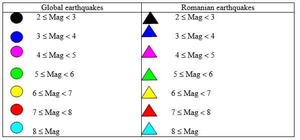
4. Updating seismic data base of our institute from CSEM using the following legend:
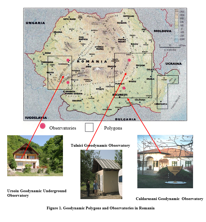
As usual, we remind a few important features of geodynamics observatories network coordinated by the Institute of Geodynamics of the Romanian Academy. This network is composed of three polygons: Căldăruşani-Tulnici geodynamic polygon, Crăciuneşti-Deva, Sarmizegetusa-Regia, Padeş-Gorj geodynamic polygon and Delta Dunării – Mangalia geodynamic polygons (Fig.1).
The Geodynamics Observatory Căldăruşani is located in the Romanian Plain (26 ° 16’12” longitude, 44°40’36 ” latitude and altitude h = 75 m above), about 40 km N-NE of Bucharest, in a region associated with more active geodynamic stages, and an important fault (Intramoesic fault). The location of the observatory in this area allows the collection of useful information on the effects of the displacement of tectonic compartments, important information for understanding the mechanisms that lead to the accumulation of energy and the earthquakes triggering in the Vrancea region.
The Underground Geodynamic Observatory Ursoiu (22°53’51” longitude and 46°00’43 latitude) is situated at 470 m above sea level, in an old mine shaft, having between 600m and 800m from the entrance to the gallery, rooms with sealed doors to reduce drafts.
The Underground Geodynamic Observatory Crăciuneşti (22°52’28” longitude and 46°00’47 ” latitude) is located in a disused mine shaft lies just north of Ursoiu observatory in similar geological conditions and altitude.
GEODYNAMIC SENSORS FOR CRUST DEFORMATION MEASUREMENTS
Analysing the geodynamic phenomena by continuous recording of the crust deformations, indirect measurements were carried out, based on measurements of very small displacements of the sensitive elements from the system measurements. These displacements are measured by the help of displacement sensors which give a variable tension versus monitored displacement.
Water-tube tiltmeters (Figs.2 and 3) have a base of tens or hundreds of meters. For the complete recording of the variations in horizontal plane two clinometers are necessary, perpendicular on each other. Water-tube tiltmeters work in optimal conditions in a mining gallery where the temperature is constant. If the tiltmeters are situated in a location where the temperature has variations over 1oC, the measurement of the temperatures of the two terminals and the application of a temperature correction is necessary. The latter can be theoretically calculated, but it must be verified experimentally, especially in the case of tiltmeters that do not have identical environmental conditions at the two terminals.
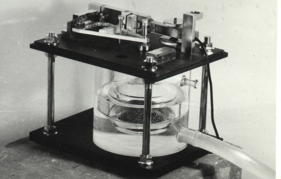
Figure 2. Water-tube tiltmeter (single terminal)
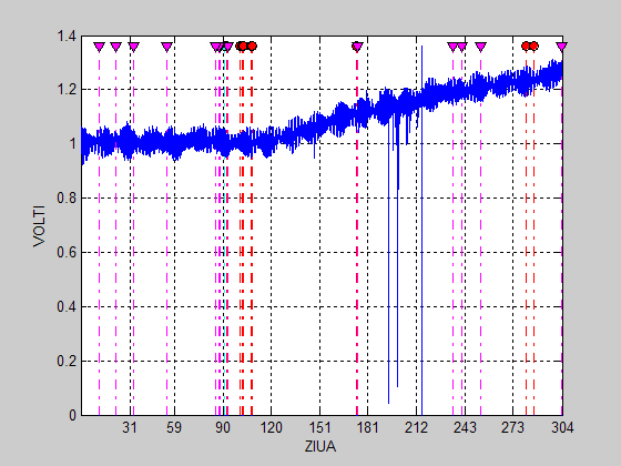
Figure 3. Tiltmeter raw recordings – 2014. URSOIU Geodynamical Underground Observatory
Tiltmeters with vertical pendulum (Fig.4) show the direction of G vector through a normal or inverse pendulum. The length of the pendulum represents the measurement base and is limited from design reasons at values of meters or tens of meters, fact that imposes a high sensitivity of the displacement sensors which are used. One pendulum can record the movement on two perpendicular directions in plane if it is equipped with displacement sensors.
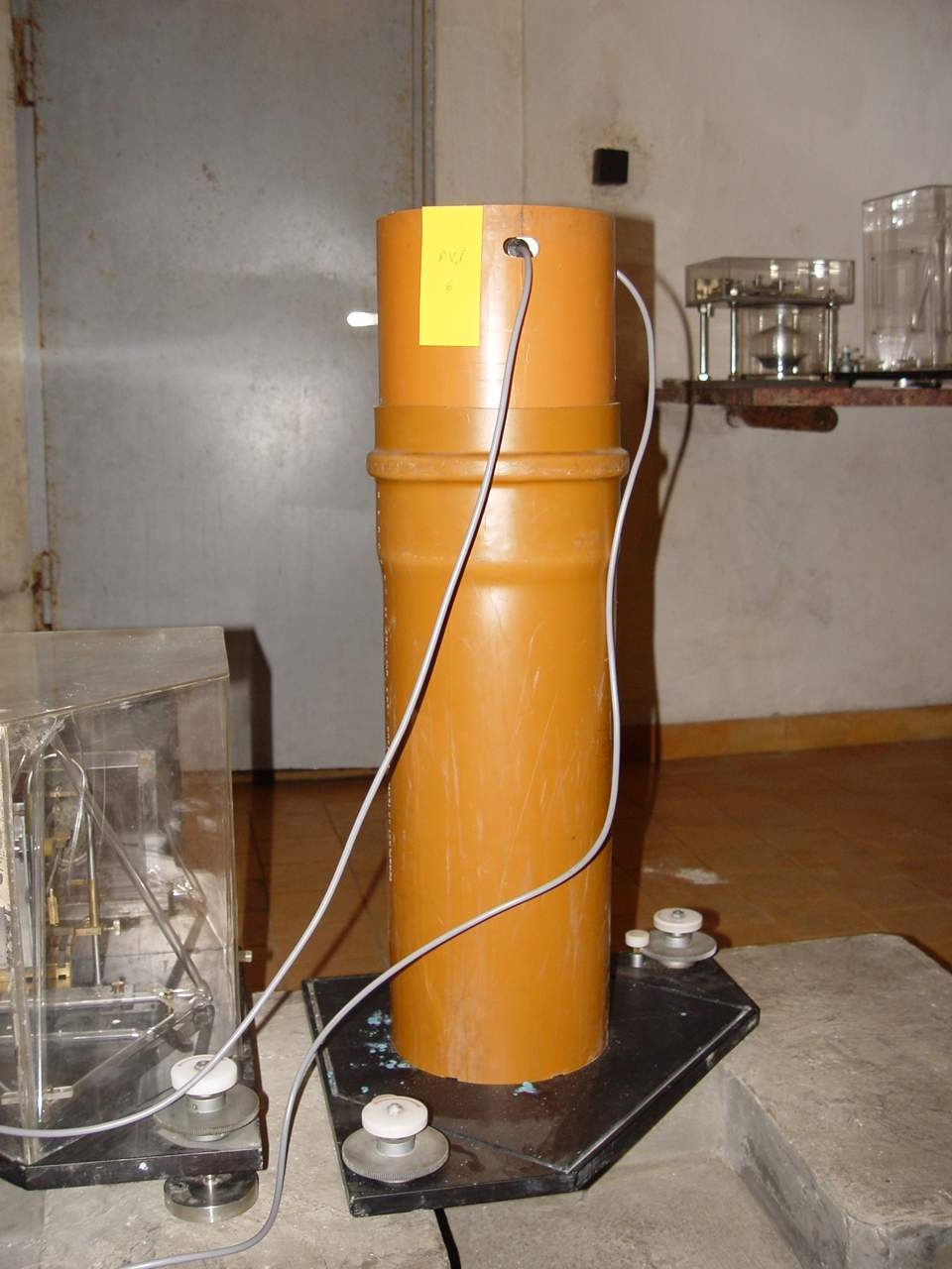
Figure 4. Vertical pendulum
The recording gravimeters (Fig. 5) for observatory are ASKANIA GS11 type. This type of gravimeter was initially designated for the field measurements, using a direct reading, carried out by an operator. The instrument was modified and adapted for a continuous recording, replacing the system for reading with a displacement sensor of high sensitivity. In this way there are carried out continuous recordings of the variations of the intensity of G vector, with a higher sensitivity than the original device. The stability of the recordings was raised, as well, by assembling the instrument in fix location, continuous electric supply and by its maintenance in chambers with small variations of temperature. Gravimeters will be assembled on a concrete pile, very deeply embedded in terrain. The setting in perfect horizontal position has to be done periodically to eliminate the possible modifications of this position meantime, fact that have a sensitive influence over the recordings.
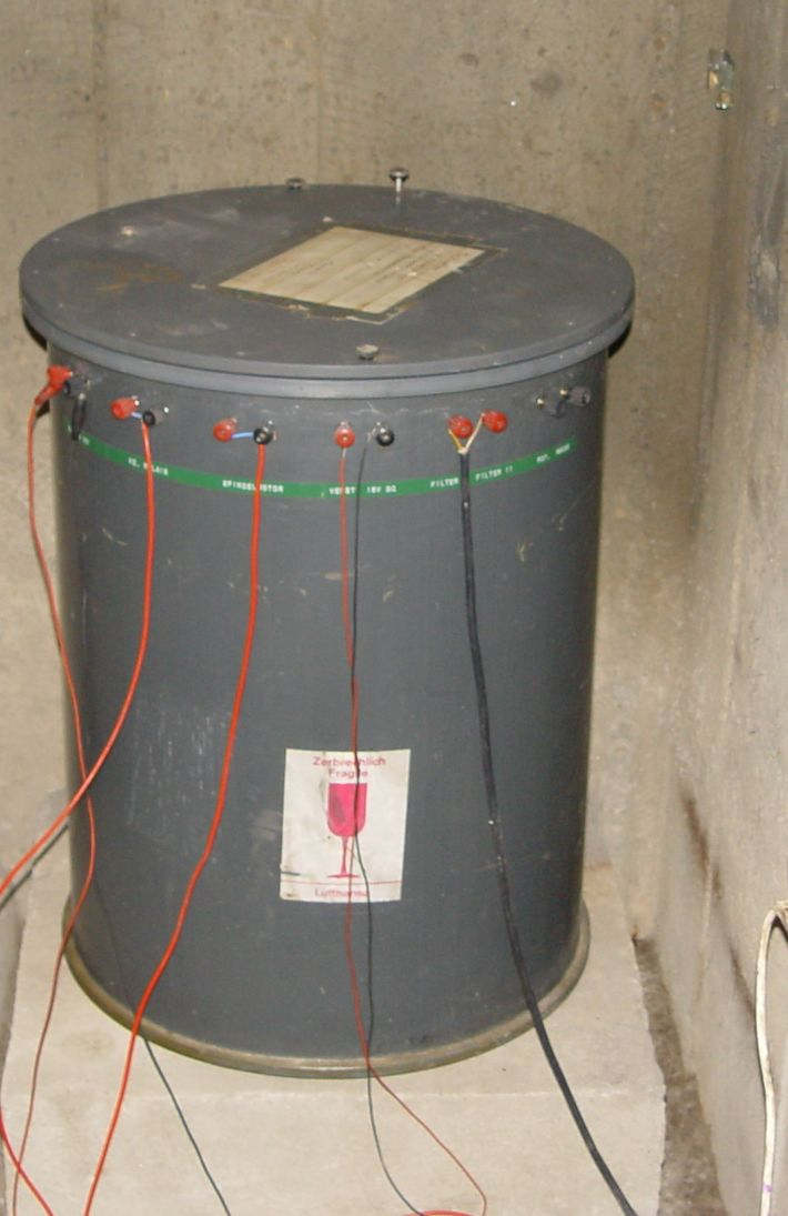
Figure 5. Askania gravimeter
The temperature of the chamber, in which gravimeter is set, must be rather constant for improving the thermostat functioning. This demand will be the best-achieved in underground observatories in which the variation of the temperature is maximum +/- 0.50C during one year.
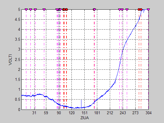
Figure 6. Gravimetric raw recordings – 2014. CALDARUSANI Geodynamical Observatory
At the other observatories the gravimeters are installed in special chambers, thermally insulated, situated in the underground, assuring a slow variation and small amplitude of temperature. In actual conditions the quasi-continuous recordings allow a good observation of the phenomenon of earth tides and allow noticing some anomalies, linked to the local conditions of surface or subsurface.
We have used the north-south and east-west records from tiltmeters, vertical records from Askania gravimeters and the records from temperature and pressure sensors (Fig.7 and Fig.8)
The atmosphere is a complex interface between outer space and Earth’s surface on the one hand, and an environment sensitive to its internal processing. From this perspective, atmospheric pressure and temperature are two important parameters whose variations can provide additional information related to the evolution of crustal deformation and, indirectly, subcrustale processes.
The air pressure changes reflected both the effect of temperature variations of the atmosphere, and the result of attraction of the Earth and its external bodies, mainly the moon and sun. In order to quantify these effects, we retained the variations of the atmospheric pressure, of the temperature and of the three directions of the crustal deformation: vertical, north-south and east-west.
ACQUISITION SYSTEM
The electronic systems of acquisition of the data are different, from the professional ones of type National Instruments on 16 bites, with own software Lab View.

Figure 7. Pressure variations from Ursoiu – 2014.
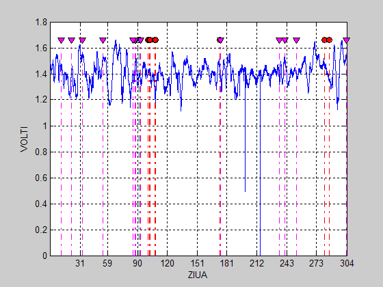
Figure 8. Temperature variations from Ursoiu – 2014
We mention that the existence of a laboratory for calibration and ageing of the geodynamic equipment (LERAG) was necessary in the framework of the activity of research for realizing performing sensors for geodynamics.
THE PRESENCE OF THE PRESSURE VARIATIONS IN THE RECORDS
The study of the of the atmospheric pressure influences on the crustal deformation is not simple. The Earth’s atmosphere, defined by highly fluctuating parameters, can be measured and survey only by advanced techniques and a dense network of observation stations. An example is the weather getting harder to do in terms of sudden changes, in terms of the variations of the coefficients of the nonlinear equations in the currently used algorithms.
Variations of different amplitudes and frequencies of some important geophysical parameter can be found in the geodynamical records (Ex: component daytime or semidiurnal). These parameters are: daily temperature variations associated with the corresponding atmospheric pressure variations, earth tides and anthropogenic activity.
We have analyzed by means of the FFT and HICUM methods, the common periods of the atmospheric pressure variations and crust deformation variations recorded by sensors mentioned in Chapter geodynamic observatories.
Processing of the data was done with the MICROGRAPH program and own programs written in MATLAB environment.
We found:
– A band of low frequency corresponding to the relatively random variation of the temperature and to the seasonal periods related to the movement of Earth’s revolution around the sun and the rotation axis inclination to the ecliptic;
* A band of frequencies corresponding to diurnal solar attraction of the Moon on air masses and frequencies “daily”due to the Earth’s rotation axis;
* A band of frequencies corresponding to the semidiurnal moon-sun attraction.
PHASE VARIATIONS OF THE AMPLITUDE FOR THE M2 EARTH TIDE COMPONENT AT THE LEVEL OF THE GEODYNAMIC OBSERVATORIES FROM ROMANIA.
Earth tides are an important natural phenomenon which causes periodical variations in the gravitational field and deformations of the earth’s interior and earth’s surface. Measurements of the Earth tides provide information on the elastic constants of the Earth (Love numbers). In contrast to earth tides, which can precisely computed, earthquakes are almost unpredictable although some investigations have shown that the elastic properties of rocks may change before earthquakes occur. If the elastic properties of rocks could be monitored it would be, in principle, possible to contribute to earthquake precursory research.
Some parameters of earth tides, as amplitude and phases of their components, are directly related to the elastic properties of rocks. Through the modeling and systematic observations of earth tide parameters related to rock elasticity it should be possible to detect precursors of earthquakes.
But measurements of the deformation of the Earth are generally complex functions of the direct response of the Earth to the deforming forces combined with instrument response, local and regional loading and crustal structure. Finding of the most appropriate method able to provide information about variations of the elastic properties of rocks remains a difficult challenge.
We have chouse to monitories the phase variations of the amplitude for the M2 Earth tide component at the level of the geodynamic observatories from Romania. This is a first step to understand the possible relation between the temporal variations of M2 phase and other local and global important geophysical phenomena (tectonically processes, seismic precursory, etc.). Our methodology is based on HiCum methods applied in sliding windows on the time series of gravimetric and tilt records.
DISSEMINATION OF RESULTS
The researchers of the “Sabba S. Stefanescu” Institute of Geodynamics of the Romanian Academy were present with a lot of scientific communications to prestigious national and international symposium, conferences and workshops. Their scientific activity is also reflected in many papers published in appreciated scientific revues.
International cooperation
Virtual International Laboratory of Geodynamics (2001-to present) – “Sabba S. Stefanescu” Institute of Geodynamics of the Romanian Academy in cooperation with the United Institute of Earth Physics “O. Yu. Schmidt” of the Russian Academy of Sciences
CIPACT 930173-ERB-351 PL 926540 Contract, Co-operation Programme between the Royal Observatory of Belgium and the Institute of Geodynamics of the Romanian Academy – studies of the influences induced by earth tides on the geophysical data.
Unesco Chair in Geodynamics (2004-to present) – Agreement between the United National Educational, Scientific and Cultural Organization and “Sabba S. Stefanescu” Institute of Geodynamics of the Romanian Academy (Romania)
Research stages (2011-2012) at the Royal Observatory of Belgium in the frame program of a Phd on the theme “Studies of the gravimetrical influences induced by earth tides on the intermediate Vrancea seismic activity”
National and international Symposium
2011
Annual Scientific Conference of the Faculty of Physics of the University of Bucharest, Bucharest, June 17, 2011
CADICHEANU Nicoleta., Horia MITROFAN, Mirela-Adriana ANGHELACHE, Constantin MARIN & Alin TUDORACHE, Appraisal of a well-defined category of earthquakes: the intermediate-depth Vrancea events with NW-SE-striking fault-plane solution.
2013
17th International Symposium on Earth Tides, „Understand the Earth”,Warsaw, Poland, 15-19 April, 2013
Cadicheanu Nicoleta, van Ruymbeke Michel & Zhu Ping, On the variability of the coupling between some earth tide periodicities and earthquake triggering from three important seismic nest regions on earth.
NEMO Workshop – Numerical Modelling Using High Performance Computing Infrastructures, Bucharest, Romania, 10-11 June 2013
Cadicheanu Nicoleta, Validation of the statistical parameter of correlation between earth tides and earthquakes
2014
Annual Scientific Session of the Institute of Geodynamics of the Romanian Academy, Bucharest, January 9-10, 2014
Cadicheanu Nicoleta, Phase variations of the amplitude for the M2 Earth tide component at the level of the geodynamic observatories from Romania.
5th National Conference on Earthquake Engineering and 1st National Conference on Earthquake Engineering and Seismology, Bucharest, Romania, June 19-20, 2014
Mirela-Adriana Anghelache, Florina Chitea, Horia Mitrofan, Nicoleta Cadicheanu, Assessing possible effects of earthquakes in terms of groundwater radionuclide pollution in Cernavodă area