INTERNATIONAL COOPERATIONS
Cooperation with:
– the Royal Belgian Observatory – Belgium (Prof.Paul Paquet, Prof.Bernard Ducarme)
– the Institute for Theoretical Geodesy of the University of Bonn – Germany (Prof. Manfred Bonatz)
– the Walferdange Observatory – Grand-duché de Luxemburg (Eng. Jan Flick)
– the Institute of Earth Physics Paris – France (prof.Jean Louis LeMouël, Membre de l’Institut)

cooperation financed by the European Community, which made possible:
– a better knowledge about the space-time evolution of certain parameters causally linked with the accumulation and the release of energy related to earthquakes in the Vrancea zone, Romania;
– an extension and a development of the material basis dedicated to the study of the active geodynamic zone of Vrancea;
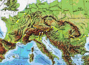
– the organization of an European Mission of Geodynamics.

The European Mission of Geodynamics – the itinerary
Cooperation with:
– the Institute of Geophysics of the University of Karlsruhe, Germany
– the Laboratory of Geophysics of Aarhus University, Denmark
– the United Institute of Earth Physics – Moscow, Russia
– the Institute of Geophysics and Geology – Kishinew, Republic of Moldavia
– the Institute of Geophysics – Bratislava, Slovac Republic
– the Institute of Geodesy and Geophysics – Sopron, Hungary
– the Institute of Nuclear Research – Debrecen, Hungary
– the Institute of Seismology and Volcanology of Hokkaido University, Japan,
– the United States Geological Survey, USA.
Project – Timing – Foreign partner (s):
Virtual International Laboratory of Geodynamics (2001-present) – “Sabba S. Stefanescu” Institute of Geodynamics of the Romanian Academy in cooperation with the United Institute of Earth Physics “O.Yu.Schmidt” of the Russian Academy of Sciences
The geodynamics features of the Po Land along the cross-sections Mestre-Chiogia-Adria-Codigoro-Portomaggiore-Alfonsine-Ravenna-Cervia-Cesenatico-Rimini and Portomaggiore-Ferrara (2002 – 2003) – Institute for Geosciences and Geo-resources in Florence (Italy)
Dynamics and structures of the SW margin of the East European Platform as inferred from geophysical data ( DEEP ) (2003 -2005) – Institute of geophysics in Kiev, National Academy of Sciences of Ukraine (IG-NASU) ; Carpathian Branch of IG-NASU in Lvov (Ukraine)
New images of the magnetic earth field in the south-east Europe (satellite data by Orsted and Champ) (program BRANCUSI) – (2003 – 2004) – Institut de Physique du Globe de Paris (France)
Unesco Chair in Geodynamics -(2004-present) – Agreement between the United National Educational, Scientific and Cultural Organization and The Institute of Geodynamics “Sabba S. Stefanescu” of the Romanian Academy (Romania)
3D modelling of the hidden structure of the crust beneath Alpine tectonics of the East Carpathians based on geophysical data interpretation, with emphasizing on the Vrancea active seismic zone: geodynamic aspects ( TRIDEC ) -(2006 – 2007 ) – Institute of geophysics in Kiev, National Academy of Sciences of Ukraine (IG-NASU) ; Carpathian Branch of IG-NASU in Lvov (Ukraine)
Geodynamic evolution of the lithosphere within the south-eastern part of East Carpathians -(2006 – 2008 )- Institut de Physique du Globe de Strasbourg (France)


