ELECTROMAGNETISM AND DYNAMICS OF LITHOSPHERE
RESEARCH FIELD
GEO-ELECTROMAGNETISM
– Near surface and deep structure investigation by magnetotelluric methodology
GEOHAZARDS EVALUATION
– Earthquakes ( geomagnetic methodology )
– (EM and DC-resistivity methodologie)
MAIN TOPICS
Elaboration and implementation of the electromagnetic (EM), geo-magnetic and geo-electric methodologies used for:
* Shallow and deep geodynamic structures’ investigation (mapping, inversion, modeling and tomographic imaging);
* Monitoring of the specific phenomena/parameters related to the natural hazards (seismicity, landslides) and risk assessment:
– Research by continuous monitoring of some geophysical parameters obtained by EM methodology to improve the pre-seismic and landslides hazard evaluation;
– Studies to integrate multidisciplinary results in the earthquake seismic hazard forecasting;
– Development of a powerful software to analyze EM parameters with a seismic precursory character.
RESEARCH INFRASTRUCTURE
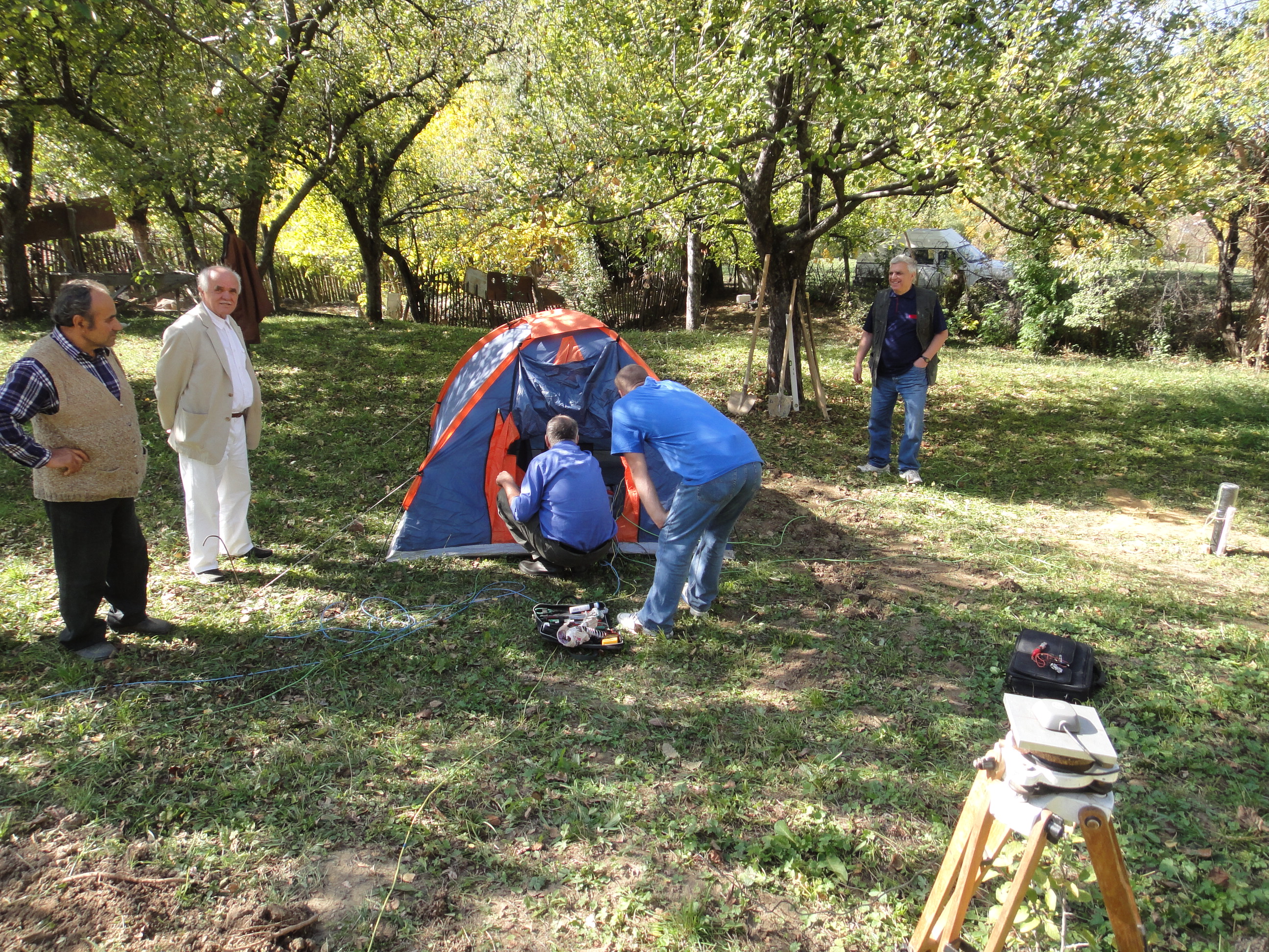
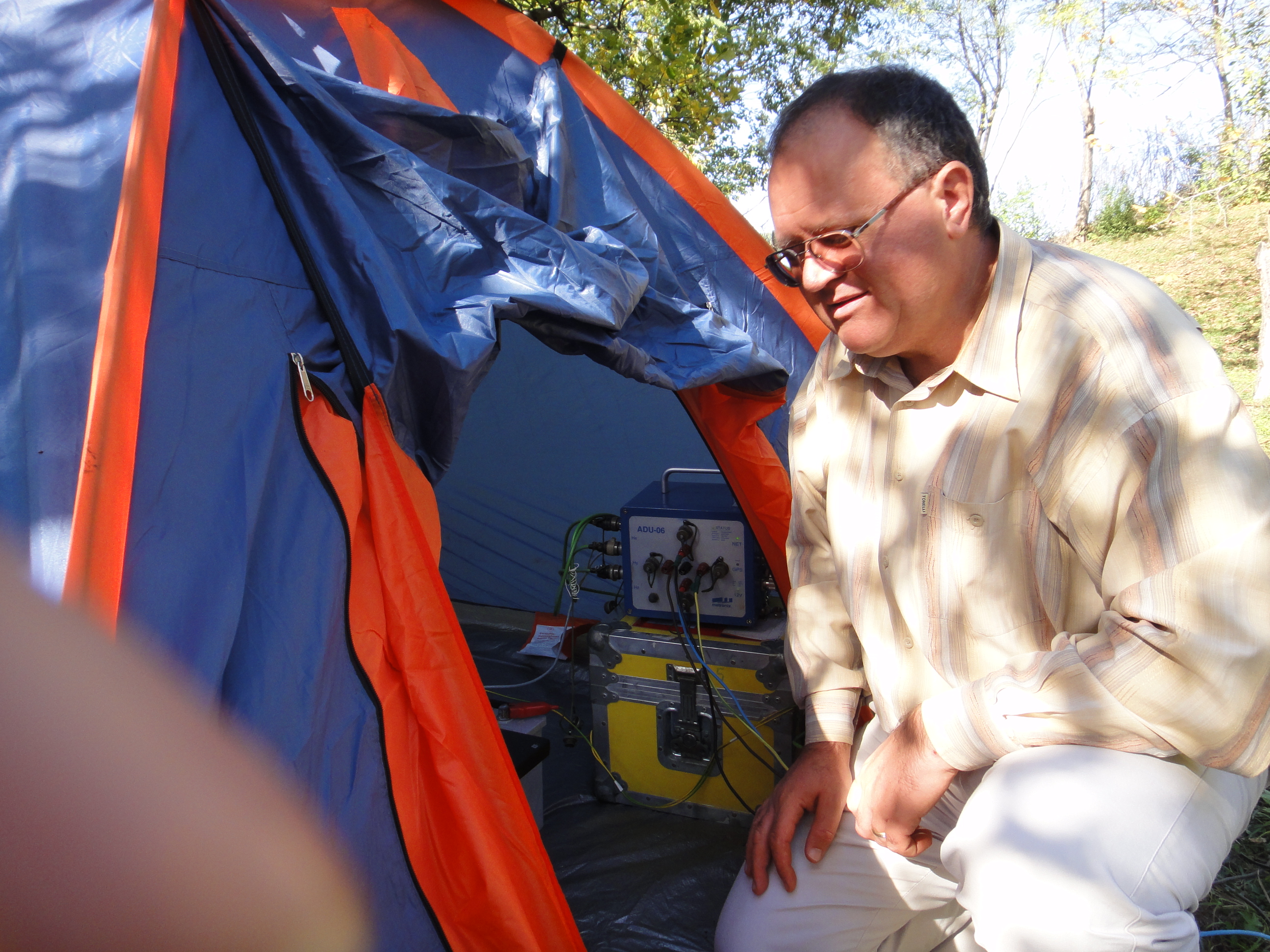
Large scale and excellent research programs including the survey and monitoring systems (GMS 06- Fig. 1, Geomagnetic system – Fig. 2, INTEL V3 Resistivimeter – Fig. 3)

Analog Digital Unit (ADU 06)
Electric sensor (EFP06)
Magnetic sensors (Hx, Hy, Hz)
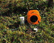
Fig.1 GMS 06 System (Metronix-Germany)
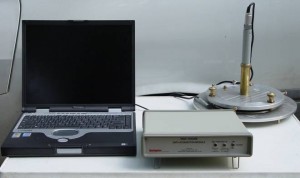
Fig. 2. Geomagnetic System Configuration
Fig. 3. INTEL V3 Resistivimeter
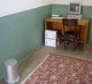
Laboratory facilities for sensors and instruments calibration (Fig. 4);
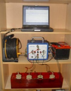
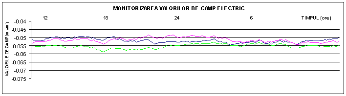
Fig. 4. Laboratory studies to determine the time stability of the electric sensors
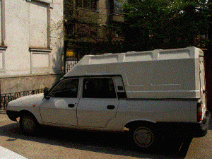
Fig. 5. Mobile laboratory of geodynamics
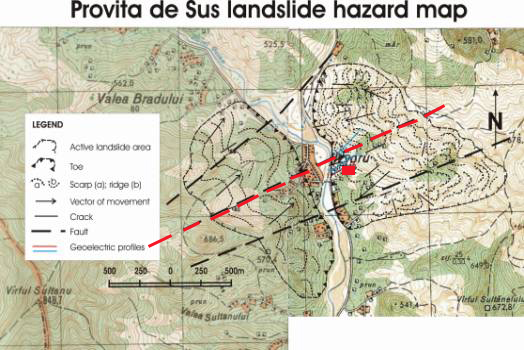
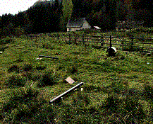
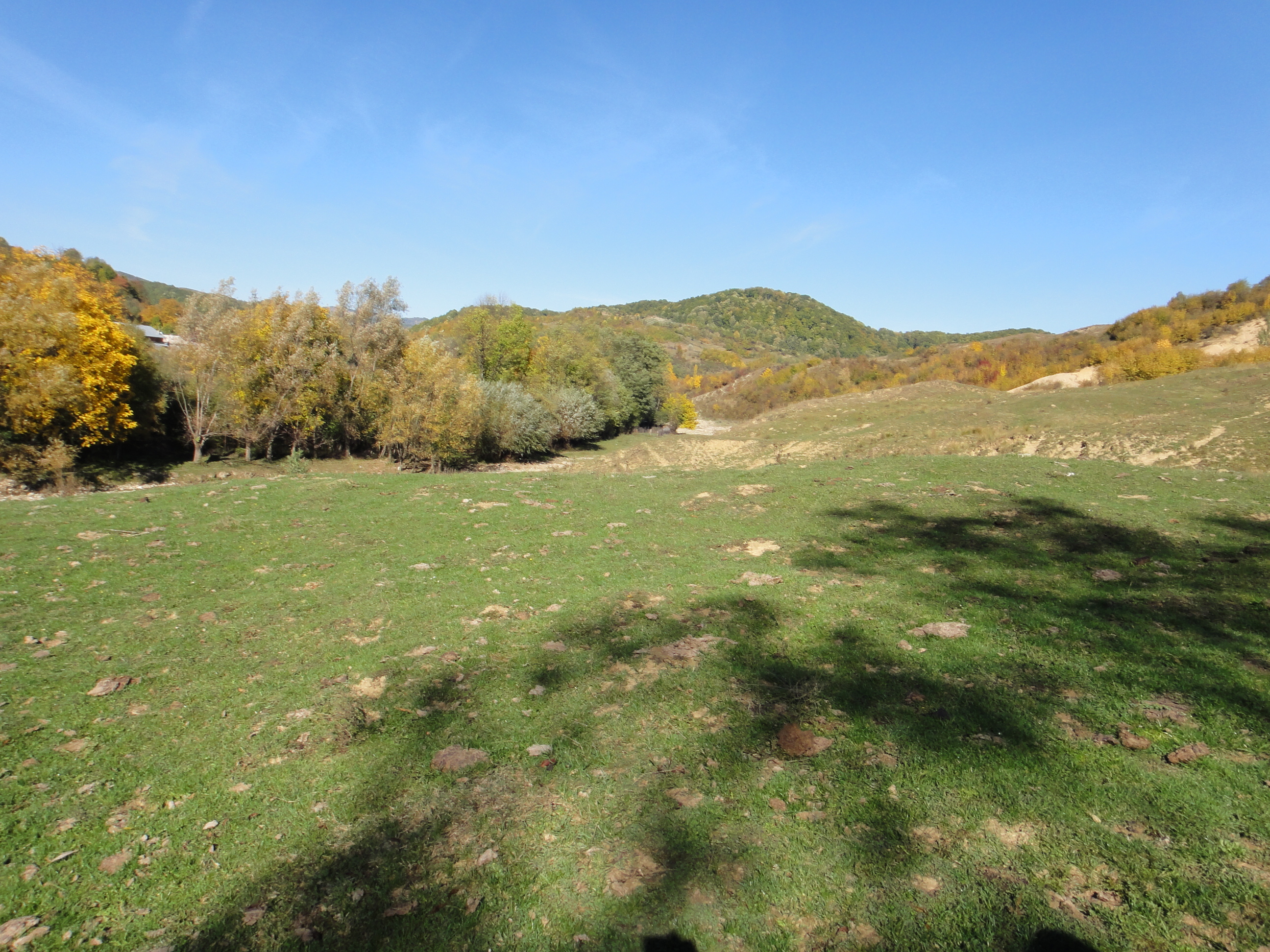
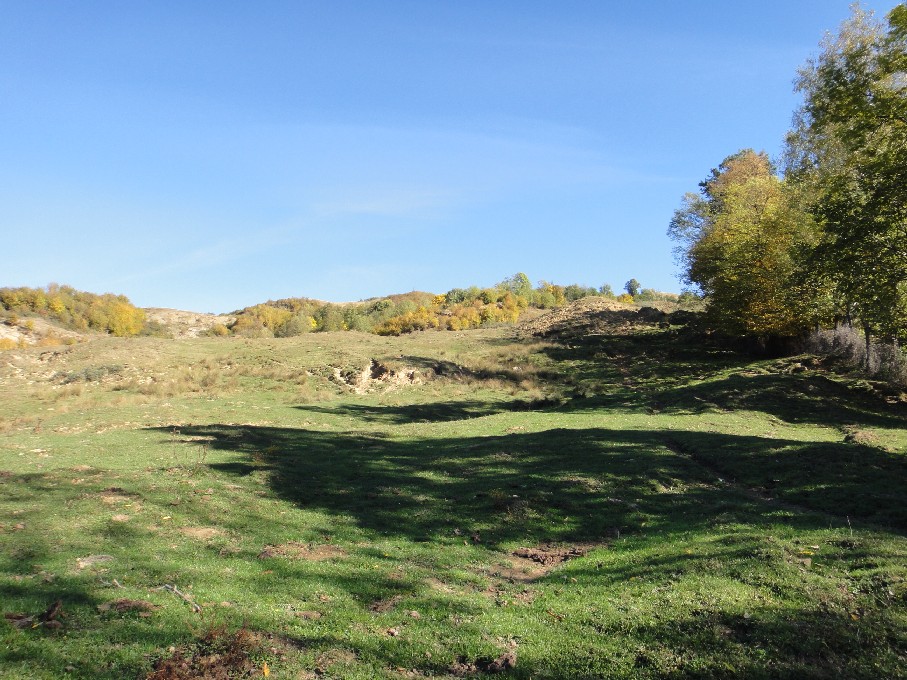
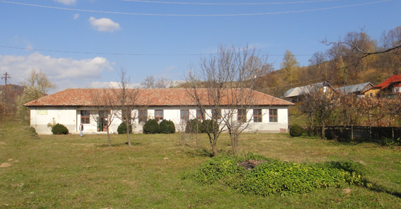
Provita de Sus Observatory – test site for the landslide monitoring (Fig. 6).

LMG este alcatuit din:
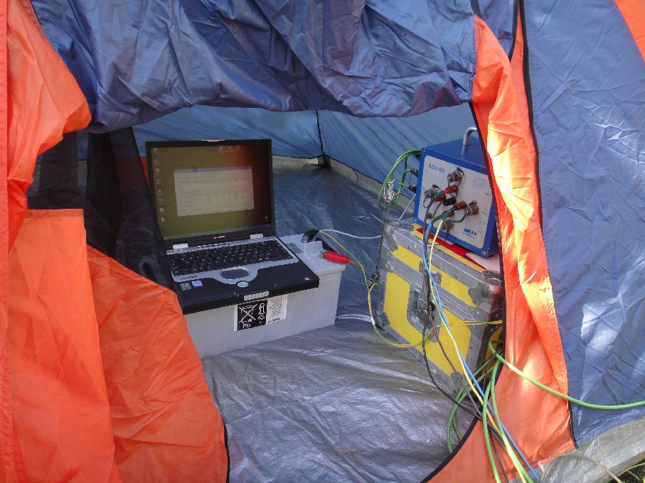
a) echipamentul electromagnetic de tip GMS 06, produs de firma Metronix – Germania, al carui mod de instalare în teren este redat în figura urmatoare. În configuratia acestui echipament exista senzori electrici (EFP-06), senzorii magnetici (Hx, Hy, Hz), ADU-06 cu unitatea de achizitie digitala, precum si laptopul care are instalat softul aferent MAPROS (Fig. 2).
Instalarea echipamentului magnetoteluric GMS-06
Echipamentul GMS-06 permite înregistrarea componentelor câmpului electromagnetic natural (Ex, Ey, Hx, Hy, Hz) pentru urmatoarele 2 benzi de frecventa:
· Banda de înalta frecventa (HF): 500 Hz – 20 kHz
· Banda de joasa frecventa (LF): DC – 1 KHz
Datele de observatie obtinute cu ajutorul echipamentului GSM-06 sunt stocate fie în memoria interna “flashdisk” , fie direct pe HDD-ul computerului de control (Laptop), pe care este instalat programul de calcul MAPROS. Acest program ruleaza sub sistemele de operare Windows 95TM sau Windows NTTM si preia controlul asupra urmatoarelor operatii relizate cu ADU 06:
1. Setarea semi-automata a senzorilor (Ex,Ey, Hx,Hy, Hz) în teren;
2. Testarea automata a tuturor senzorilor si a Unitatii Analog Digitale (ADU 06);
3. Compensarea automata a offsetu-lui si calibrarea în teren a sistemului de înregistrare;
4. Achizitia si procesarea în timp real a datelor;
5. Estimare robusta a functiilor de transfer electromagnetice;
6. Redarea în timp real a seriilor de timp si a parametrilor electromagnetici(rezistivitatea si diferenta de faza, skew, strike);
7. Realizarea bazei de date integrate, stocare si recuperare informatie.
b) sistemul de monitorizare a datelor geomagnetice de tip MAG 03 DAM (Fig. 3), utilizat pentru evaluarea parametrilor cu caracter precursor al activitatii seismice din zona Vrancea.
Sistemul de monitorizare a datelor geomagnetice
FUNDED PROJECTS
National Projects:
1. Echipament specializat mobil destinat studiilor complexe in zone geodinamic active (zone seismogene, alunecari de teren, surpari de teren in zone cu goluri subterane etc.) – EMCGA, Coordonator , 2001-2004;
2. Tehnologie şi echipament specializat destinate urmaririi câmpurilor magnetoteluric şi de stres în scopul evidentierii unor parametri cu caracter precursor seismelor vrâncene , Coordonator, 2002-2004;
3. Sistem complex de monitorizare a zonelor de risc natural ridicat datorat alunecărilor de Teren – SMALT, Coordonator , Coordonator, 2004-2006;
4. Fundamentarea unei noi ipoteze privind relaţia dintre procesul de torsiune al „slab-ului” vrâncean şi evoluţia segmentului sud-vestic al Platformei Est-Europene, cu implicaţii în producerea evenimentelor seismice – PROTORV, Coordonator , 2004-2006
International Projects:
INTEGRATED OPTIMIZATION OF LANDSLIDE ALERT SYSTEMS (OASYS), EU-FP 5 Project, partner, 2003-2006;
EXTREME EVENTS: CAUSES AND CONSEQUENCES (E2C2), EU-FP 6 Project, Partner, 2005-2008;
COST & EFS -COST Action 625 Project:3D monitoring of active tectonic structures, Partner, 2000-2006;
Stanica Dumitru
CURRICULUM VITAE
Dr. Dumitru Stanica
E-mail: dstanica@geodin.ro
Personal and education
Born: March 09, 1945
Graduated from the Institute of Oil, Gaze and Geology – Faculty of Geophysics, Bucharest, 1968
PhD. Geophysics (electromagnetism), University of Bucharest, 1987Professional Association
Member: European Geosciences Union (EGU), IAGA (Working group I.1.), IAGA+IAVCEI+IASPEI (WG-EMSEV), Management Committee of the COST Action 625, Geophysical Society of Romania, Society of Exploration Geophysicists,.Publication
More than 110 papers and abstracts published in Romanian and international journals, in electromagnetism (EM), geomagnetism and EM precursory phenomena/parameters of earthquakes, lithosphere rheology – conductivity relationship, dynamical modeling of lithosphere evolution, natural and anthropic hazard assessment.Capabilities
Elaboration and implementation of the electromagnetic and geoelectric methodologies used for:
- Shallow and deep structure investigation (mapping, inversion and modeling);
- Continuous monitoring of the specific phenomena/parameters related to the natural hazards (landslide, land collapse and seismicity).
Training and experience
- 1981- University of Sankt Petersburg- “International course of Electromagnetism” organized under United Nations co-ordination.
- 1992-1998; 2004 -2005 Associate Professor at the University of Bucharest
- Viziting Professor at the Naples (1982), Pisa (1984, 1986, 1990) and Padua (1982, 1984) Universities.
- Coordinator and collaborator of the international projects Europrobe (PANCARDI and ALCAPA – 1992-2001), COST ACTION 625 (2001-2006), IGCP-430 (2001-2004), EU- PC5 (OASYS and SAMCO projects) PC6 (NEST-2003-Path-1, 2005,Extreme Events: Causes & Consequences (E2-C2) project),
- Mutual co-operation programs with the institutes belonging to the Naples (1982), Pisa (1984, 1986, 1990) Padua (1982,1984,) and Goettingen (1998) Universities and academic institutes from Prague, Sopron, Warsaw.
- Coordinator of the National Program “ MENER” ( Projects: Risk management for landslides and seismicity- 2001-2004, 2004-2006), “CERES” (PROTORV project), etc.
Career to date
– 1968-1990: Scientific researcher (senior researcher since 1982) in the institutes where the fundamental research in Geophysics has been carried out in successive reorganization of the scientific research activity in Romania (Institute of Applied Geophysics, Institute of Geology and Geophysics, Geological Institute of Romania and Romanian Academy-Institute of Geodynamics);
– 1990-2006: Head of departments in the Institute of Geology and Geophysics, Geological Institute of Romania and Romanian Academy-Institute of Geodynamics.
– Since 2006: Deputy Director – Institute of GeodynamicsList of selected publications:
Stănică D., Stănică Maria, Plaviţă Ramona: A new processing method of telluric current data. Acta Gelogica Academiae Scientiarum Hungaricae,Tomus 21(4),.363-371,Budapest, 1977.
Stănică D., Stănică Maria: Crust and upper mantle investigation by magnetotelluric soundings in Romania.Acta Geodaet.,Geoph. Mont.Hung.19(1-2),147-152,Budapest, 1984.
Stănică D., Stănică Maria, Visarion M.: The structure of the crust and upper mantle in Romania as deduced from magnetotelluric data.Rev.Roum.Geol.,Gephys.et Geogr.-Geophysique,30, 25-35,Bucarest,1986
Stănică D.: Contributions at the deciphering of the deep geological structure of Moesian Platform by means of the telluric current method. Ph.D.Thesis. University of Bucharest, p.154, 1987.
Stănică D., Stănică M.: The investigation of the deep structure of the Moesian Platform (Romania) by means of electromagnetic induction methods. Gerlands Beitr. Geophysik. Leipzig, 98, 2, 155-163, 1989.
Stănică D., Stănică Maria in Chekunov A.V., et al.: The geotransect from the Dnepr-Donets paleorift via the Ukrainian Shield tothe South Carpathians. Geophysical Journal, Volume 10, No.6, 723-763, Gordon and Breach Science Publisher,1991, ISSN: 0275-9128.
Stănică D., Stănică Maria : An electrical resistivity lithospheric model in the Carpathian Orogen from Romania. Physics of the Earth and Planetary Interiors, 81(1993),.99-105. Crustal – Scale Studies, Elsevier Science Publishers B. V., Amsterdam, 1993. ISSN: 0031-9201
Dumitru Stănică and Maria Stănică : 2 D modelling of the geoelectrical structure in the area of the deep-focus Vrancea Earthquakes. In Monography of Southern Carpathians, Reports on Geodesy, no.7(37), Inst. of Geodesy and Geodetic Astronomy, pp.193-203, Warsaw, 1998.
D.Stanica, M.Stanica, D.Zugravescu: Geodynamic evolution of the Vrancea seismogenic area revealed by magnetotelluric tomography. St.cerc. Geofizica, tomul 37,. 61-69, 1999, Bucuresti.ISSN: 1220-5265.
Stănică M., Stănică D., Marin-Furnică C.: The Placement of the Trans-European Suture Zone by Electromagnetic Arguments on the Romanian Territory. In Monography of the Electromagnetic Induction in the Earth (papers presented at the 14th workshop in Sinaia, august, 1998), D. Stănică and J. Weaver (Guest Editors). Earth, Planets and Space, 51, 1073-1078, Japan, 1999, ISSN: 1343-8832.
Dumitru Stănică, Maria Stănică, Laurenţiu Asimopolos:The main Tethyan suture zone revealed by magnetotelluric tomography. Rev.Roum.de Geophysique, 44, p.123-130, 2000,Bucarest, ISSN 1220-5303.
Dumitru stănică and Maria stănică: Geodynamic twist process of the seismogenic slab-a new attempt to explain the earthquakes’ mechanism of the Vrancea zone. 16-th Workshop on EMI in the Earth, Santa Fe, New Mexico, USA, June 16-22, 2002.
Dumitru stănică, Maria stănică and Dorel Zugrăvescu: ULF electromagnetic phenomena connected with Vrancea (Romania) seismic events. 16-th Workshop on EM Induction in the Earth, Santa Fe, New Mexico, USA, June 16-22, 2002
D. Stănică, M. Ivascu, D. Zugrăvescu : Geophysical equipment meant for complex studies in geodynamic active zones. R.J.of Physics, Vol. 55, No.4, 619-625, 2003.
D. Stănică, M Stănică: Methodology and equipment used for emphasizing the short-term electromagnetic (EM) precursory parameters of the Vrancea’s earthquakes. The XXIII General Assembly of the International Union of Geodesy and Geophysics, June 30-July 11, 2003, Sapporo, Japan. Abstract Volume, A.186.
D. Stănică and Dorel Zugrăvescu: Mobile geophysical laboratory: electromagnetic, electric and seismo-acustic analysis. Proceedings of the International workshop COST ACTION 625 “Active Faults: Analysis, processes and monitoring”, Studi Geologici Camerti. Special Issue, EDIMOND Volume, 131-134, 2004.
D. Stănică, M. Stănică and Dorel Zugrăvescu: The electromagnetic precursory phenomena associated with the earthquakes occurred in the Vrancea seismogenic zone. Proceedings of the International workshop COST ACTION 625, “Active Faults: Analysis, processes and monitoring”, Studi Geologici Camerti. Special Issue, Volume 2004, p.135-138.
D. Stănică, M. Stănică, L. Picardi, E. Tondi, Giusepe Cello: Evidence of the geodynamic torsion in the Vrancea zone (Eastern Carpathians). Rev. Roum. GEOPHYSIQUE, 48,15-19, Bucharest, 2004
D. Stănică: New Approach to the Electromagnetic Precursors, 8th Workshop on Non-linear Dynamics and Earthquakes Prediction, 3-15 October 2005. The Abdus-Salam International Centre for Theoretical Physics (ICTP), Lecture Notes (p.1-13), 2005 on http://agenda.ictp.trieste.it/ smr.php?1676
Maria Stanica, Dumitru Stanica, Constantin Diacopolos and Marian Popescu, Ground-base monitoring system on the active faults associated with seismic events. Abstract Volume at the 18-th International Workshop on Electromagnetic Induction in the Earth, El Vendrell, Spain, on: http://www.ub.edu/18emiw/Program.html, 2006.
Dumitru Stanica, Maria Stanica and Madalina Visan, Electromagnetic precursory parameters related to the intermediate depth earthquakes (Romania), Abstract Volume at the 18-th International Workshop on Electromagnetic Induction in the Earth, El Vendrell, Spain, on: http://www.ub.edu/18emiw/Program.html, 2006.
D. Stănică, M. Stănică and M. Vişan, Anomalous behavior of the electromagnetic parameters associated to intermediate depth earthquakes. Rev. roum. GEOPHYSIQUE, nr. 50, Bucharest, 2006.
D. Stanica and Maria Stanica, Electromagnetic monitoring in geodynamic active areas, Acta Geodinamica et Geomaterialia, Czech Republic, 2006.Stanica, D., Stanica, M., Vladimirescu, N., Changes of electromagnetic (EM) pattern generated by seismic activity. EGU, Geophysical Research Abstracts, Volume 9, 01536, Vienna , Austria , 2007, ISSN: 1029-7006.
Stanica, D., Stanica, M., The main structural features of the Carpathian arc bend zone in connection with the torsion process of the seismogenic relic slab (Vrancea region). EGU, Geophysical Research Abstracts, Volume 9, 01589, Vienna , Austria , 2007.
Popa, M., Cadichian, N., Romashkova, L.L., Radulian, M., Stanica, D. Kossobokov, V.G., Seismic monitoring aimed at intermediate-term prediction of strong earthquakes in the Vrancea region. EGU, Geophysical Research Abstracts, Volume 9, 06563, Vienna , Austria , 2007, ISSN: 1029-7006.
A. Ruiz-Constan, J. Galindo-Zaldivar, A. Pedrera, C. Marin-Lechado, D. Stanica, M. Stanica, Crustal detachement and seismicity distribution: new constraints from MT data in Central Betic Cordilleras , Geophysical Research Abstracts, Volume 9, 09655, Vienna, Austria, 2007, ISSN: 1029-7006.
D. Stanica, Electromagnetic monitoring system for the natural hazard assessment due to seismic and landslide activities, Proceeding Volume at the National Symposium of Geology and Geophysics – GEO2007, 113-117, Bucharest .
Stanica, D., Stanica, M., Vladimirescu, N., Changes of the electromagnetic parameters used as possible seismic premonitory signals. IUGG, Perugia , Italy , 2007.
Stanica, D. Stanica, M., Diacopolos, C., Early-warning system for risk mitigation due to the landslides triggered by seismic activity. IUGG, Perugia , Italy , 2007.
D. Stanica and Maria Stanica, Electromagnetic monitoring in geodynamic active areas, Acta Geodinamica et Geomaterialia, Vol.4, No. 1(145), 99-107, Prague, 2007.
J.Galindo-Zaldivar, A.Gil, C.Sanz de Galdeano, S.Shanov and D. Stanica, Monitoring of active tectonic structures in Central Betic Cordillera (Southern Spain), Acta Geodinamica et Geomaterialia, Vol 4, No.1(145), 19-29, Prague, 2007.
D. Stanica, Earthquakes and landslides in the Carpathian area – Romania , Lecture Notes (12 pages) at E2C2-GIACS Advanced School, Extreme Events: Nonlinear Dynamics and Time Series Analysis, Comorova-Romania, 3-11 September 2007
D. StAnica and M. Stanica, Modeling of Block and Fault Systems of the Active Vrancea Zone (Eastern Carpathians-Romania); Evidence of the Geodynamic Torsion Process, the Ninth Workshop on Non-linear Dynamics and Earthquakes Predictions The Abdus-Salam International Centre for Theoretical Physics (ICTP), 01-13 Oct. 2007, electronic paper (11 pages as Pdf.) on http://www.agenda.ictp.trieste.it/ smr.php? 1864-3
D. Stanica, M. Stanica, and C. Diacopolos, Real time Ground-base monitoring system for earthquakes and associated natural hazards assessment and risk mitigation, the Ninth Workshop on Non-linear Dynamics and Earthquakes Predictions, the Abdus-Salam International Centre for Theoretical Physics (ICTP), 01-13 Oct. 2007, electronic paper (11 pages as Pdf.) on http://www.agenda.ictp.trieste.it/smr.php?1964-1
D. Stanica and M. Stanica, S pecific electromagnetic approaches related to the short – term precursory parameters associated to intermediate depth earthquakes (Vrancea zone, Romania), the Ninth Workshop on Non-linear Dynamics and Earthquakes Predictions, the Abdus-Salam International Centre for Theoretical Physics (ICTP), 01-13 Oct.2007, electronic paper (11 pages as Pdf.) on http://www.agenda.ictp.trieste.it/ smr.php? 1964-2
D. Stanica, Associated natural hazards: Earthquakes and landslides, reflected in the electromagnetic data, abstract at the Third International Conference CEI, Bucharest , Romania , 24-26 October, 2007
Dumitru Stanica and Dragos Armand Stanica, An improved geodynamic model for the seismic active Vrancea zone, Romania, EGU, Geophysical Research Abstracts, Volume 10, Vienna, Austria, 2008, ISSN: 1029-7006.
Dumitru Stanica, Dragos-Armand Stanica, Nicoleta Vladimirescu and Marian Popescu: Ground-based monitoring technique used to emphasize the precursory electromagnetic marks associated to the Vrancea’s intermediate depth earthquakes (Romania), EGU, Geophysical Research Abstracts, Volume 10, Vienna, Austria, 2008, ISSN: 1029-7006.
Dumitru Stanica, Maria Stanica and Constantin Diacopolos, Real-time electromagnetic monitoring system for landslides assessment due to the seismic activity, E GU, Geophysical Research Abstracts, Volume 10, Vienna, Austria, 2008, ISSN: 1029-7006.
Dragos Armand Stanica, Dumitru Stanica and Constantin Diacopolos, Real–time monitoring system for risk mitigation due to the landslides triggered by seismic activity, 33 rd International Geological Congress, Oslo , August 2008.
Dumitru Stanica and Maria Stanica, G eodynamic torsion process of the seismogenic relic slab and the intermediate depth seismicity of the Vrancea zone, EMSEV-DEMETER joint workshop, Program and Abstracts,1.1, 19, Sinaia, September, 2008 (în Pdf. format pe http://www.geodin.ro/ ~prezentare/EMSEV/emsev.html ).
D. Stanica, D.A. Stanica, N. Vladimirescu and M. Popescu, S hort-term EM precursory parameters related to the intermediate depth Earthquakes, EMSEV-DEMETER joint workshop, Program and Abstracts, 2.14, 36, Sinaia, September, 2008 (in Pdf. format pe http://www.geodin.ro/~prezentare/ EMSEV/emsev.html ).
D. A. Stanica, D. Stanica and C. Diacopolos, Ground-base monitoring system for the natural hazards assessment due to landslide activity, EMSEV-DEMETER joint workshop, Program and Abstracts, 6.2, 75, Sinaia, September, 2008 (în Pdf. format pe http://www.geodin.ro/~prezentare/ EMSEV/emsev.html ).
Dumitru Stanica, Armand Stanica and Marian Popescu , National Geophysical Observatory Surlari used for monitoring of the Electromagnetic Prercursory Parameters Related to Intermediate Depth Earthquakes, 3 rd Anniversary Symposium GeObMag 2008, proceedings, p.22-26, Bucharest , October 2008
D. Stanica and D. A . Stanica: Relationship Between the Deep Structure and Geodynamics of the Carpathians’ Arc Bend , 19-th IAGA -WG1.2. Workshop on Electromagnetic Induction in the Earth, electronic paper, Vol.1, S1.2_E05, 137-142, Beijing , 2008, http://www.19emiw.cn/Abstracts_Vol_1.pdf
D. A. Stanica and D. Stanica, A specific ground-base monitoring system for the landslides activity, 19-th IAGA -WG1.2. Workshop on Electromagnetic Induction in the Earth, Vol.1, S1.1_S10, 92, Beijing , October 2008
D. Stanica , D. A. Stanica, M. Popescu, N. Vladimirescu: S urveying the seismic hazard by using ground based analysis of Earth’s electromagnetic field , EGU, Geophysical Research Abstracts, Volume 11, April, Vienna, Austria, 2009, ISSN: 1029-7006.
D.A. Stanica, M. Stanica and C. Diacopolos : E lectromagnetic studies on geodynamics related to the landslides associated to the seismic events , EGU, Geophysical Research Abstracts, Volume 11, April, Vienna, Austria, 2009, ISSN: 1029-7006.
M. Stanica and D. Stanica: Vrancea zone geodynamics and the explanation of the earthquakes mechanis m , Abstracts Volume at JPGU Meeting, May 2009, Chiba , Japan .
D. Stanica and M. Stanica: Electromagnetic methodology on seismic hazard assessment, Abstracts Volume at JPGU Meeting, May 2009, Chiba , Japan
Dumitru STANICA and Maria STANICA : Earthquake-induced landslides geohazard assessment (south Subcarpathians) by using electromagnetic data, Abstract Volume IAGA meeting, August 23-30, 2009 , Sopron , Hungary .
Stanica D, Stanica D.A., 2009, Constraints on correlation between the anomalous behaviour of electromagnetic normalized functions (ENF) and the intermediate depth seismic events occurred in Vrancea zone ( Romania ), Terr. Atmos. Ocean . Sci. Journal, in print
Stanica D, Stanica D.A., 2009, Carpathian electrical conductivity anomaly (CECA) acting as high sensitive path to emphasize the EM precursory parameters associated to seismic events. In: Papers Collection of the 9 th International Geo-electromagnetic Workshop (CIGEW), China , 4-7.
Stanica D.A., Stanica Maria, Diacopolos C, 2009 , Electromagnetic responses in the seismic induced landslides areas. In: Papers Collection of the 9 th International Geo-electromagnetic Workshop (CIGEW), China , 8-10.
Dumitru Stanica and Dragos Armand Stanica, 2009, Electromagnetic responses related to intermediate-depth earthquakes within Vrancea zone, Conference Abstracts, International Experts Meeting on Carpathian Geodynamic Network, 19-21 November 2009, Bucharest, 15.
Dragos Armand Stanica, Near-Real Time Analysis of the Electromagnetic Precursors for Seismic activity, AOGS, Program and Abstracts, IWG07, p343, Singapore, 2009, ISBN 978-981-08-2846-2
Stanica Maria
Stanica Maria
– Scientific researcher II
Competence domains:
Geophysics: Electromagnetism, Electrometry, Geomagnetism
Activity domains:
a) Elaboration of methodologies and models in the competence domains;
b) Study of the structure of the crust and upper mantle of the Earth;
c) Study of the natural geo-hazard phenomena (earthquakes and landslides) concerning the analysis and assessment of risk level.Theorethical and practical results:
a) Elaboration of new procedures, methodologies and technologies in the competence domain:
– Stanica D., Stanica Maria, Plavita Ramona: A new processing method of telluric current data. Acta Gelogica Academiae Scientiarum Hungaricae,Tomus 21(4),pp.363-371,Budapest, 1977.
– Stanica D., Stanica Maria, Plavita R., Cucu G.: Some techniques of magnetotelluric data processing. Rev.Roum.Geol.,Geophys unor activitati geofizice noi.et Geogr.-Geophysique, 22, pp. 107-112, Bucarest, 1978.
– D. Stanica, Maria Stanica and Dorel Zugravescu: Seismic Hazard Assessment by Electromagnetic Monitoring of the Vrancea Zone, II International Workshop on Geo-Electro-Magnetism, Lerici, La Spezia, Italy, 24-28Sept. 2001.
– Dumitru stanica and Maria stanica: Geodynamic twist process of the seismogenic slab-a new attempt to explain the earthquakes’ mechanism of the Vrancea zone. 16-th Workshop on EMI in the Earth, Santa Fe, New Mexico, USA, June 16-22, 2002b) Study of the structure of the crust and upper mantle of the Earth (Elaboration of deep structural models in Vrancea zone and along the Geotraverses on Romanian territory):
– Stanica D., Stanica Maria : An electrical resistivity lithospheric model in the Carpathian Orogen from Romania. Physics of the Earth and Planetary Interiors, 81(1993),. Crustal-Scale Studies, Elsevier Science Publishers B. V., Amsterdam, p.99-105, 1993.
– Stanica M., Stanica D.: Magnetotelluric studies in the Tethian Suture Zone on the Pannono-Carpathian geotransect.Rev., Roumaine de Geophysique,Tome 40, p 71-80, 1996.
– Stanica D., Stanica Maria: 2 D modeling of the geoelectrical structure in the area of the deep-focus Vrancea Earthquakes. Monograph of Southern Carpathians, Reports on Geodesy, no.7(37), Inst. of Geodesy and Geodetic Astronomy, Warsaw, p.193-203, 1998
– Stanica M., Stanica D., Marin-Furnica C.: The Placement of the Trans-European Suture Zone by Electromagnetic Arguments on the Romanian Territory. Earth, Planets and Space, 51, 1073-1078, Japan, 1999
c) Study of natural geo-hazard phenomena (earthquakes and landslides) concerning the analysis and assessment of risk level.
Maria Stanica, Dumitru Stanica, Constantin Diacopolos and Marian Popescu: Ground-base monitoring system on the active faults associated with seismic events. Abstract Volume at the 18-th International Workshop on Electromagnetic Induction in the Earth, El Vendrell, Spain, 2006. Expanded abstract, 4 pages (web page:http://www.ub.edu/18emiw/Program.html);
- – Dumitru Stanica, Maria Stanica: Extreme Events (Earthquakes and Landslides) Reflected by the Electromagnetic Parameters, EMSEV2005 Abstracts Notebook, p.19-23, Nov. 2005, Puerto Vallarta, Mexico.
- – D. Stanica, M. Stanica, M. Tatu, M. Popescu, C. Diacopolos, V. Rădulescu: Monitoring complex system of the natural high risk zones due to landslides (Sistem complex de monitorizare a zonelor de risc natural ridicat datorat alunecărilor de teren), Abstract, p.75-78, MENER 2005, Bucureşti, 20-21 Oct. 2005, Univ. Pol. Bucureşti
- – D. Stanica, M. Stanica, V. Radulescu: Geophysical methodology focused on natural hazard assessment due to extreme events (earthquakes and landslides) occurred on the Romanian territory, EUG-Abstracts, 24-29.04 2005, Vienna
– D. Stanica, M. Stanica, M. Tatu, C. Diacopolos: Geophysical measurement system (GMS) used for
real-time monitoring of landslides in active tectonic zones (Provita and Doftana valleys) – Romania,
Abstract Volume-OASYS Project, 3-4.02.2005, Modena, Italy
Stanica Armand
Curriculum Vitae
– IANUARIE 2015 –
- Nume: Stănică
- Prenume: Dragoş Armand
- Data naşterii: 10.10.1969
- Cetăţenia: Română
- Studii:
| Instituţia | Şcoala Naţională de Studii Politice şi Administrative, Bucureşti | Academia de Studii Economice/Facultatea de Finanţe, Bănci şi Burse de Valori, Bucureşti | Facultatea de Electronică şi Telecomunicaţii, Bucureşti |
| Perioada: | 2005 – 2007 | 1994 – 1998 | 1989 – 1993 |
| Grade sau diplome | – MASTER | – LICENŢĂ |
- Titluri ştiinţifice:
– Master in “Puterea Executivă şi Administraţie Publică” –
– Doctor in “Ştiinte ale Vieţii şi Pământului“ – Geologie (cu calificativul “Excelent”)
- Experienţa profesională:
| Perioada | 1988-1995 | 1999-2007 | 2007- prezent |
| Locul: | Bucuresti | Bucuresti | Bucuresti |
| Instituţia: | Institutul de Geologie si Geofizica | ANAFDGFPI | Institutul de Geodinamică al Academiei Române |
| Funcţia: | Electronist | Inspector principal | Cercetător ştiinţific |
| Descriere: | Elaborarea hărţilor naţionale de curenţi telurici; Studiul stucturii geologice profunde pe teritoriul României, prin metode electromagnetice | Control si rambursare TVA | Studii metodologice privind lărgirea domeniului de aplicare a cercetării geofizice în zone geodinamic active, în special în arealul seismo-activ Vrancea |
- Locul de muncă actual şi funcţia: Institutul de Geodinamică al Academiei Române, cercetător ştiinţific
- Vechimea în funcţia actuală: 16 ani (1988-1995; 2007-2014)
- Membru al asociaţiilor profesionale:
– AGU (American Geophysical Union),
– EGU (European Geosciences Union),
– JPGU (Japan Geoscience Union),
– AOGS (Asia Oceania Geosciences Society),
– EMSEV (Electromagnetic Studies for Earthquakes and Vulcanoes)
- Limbi străine cunoscute: Egleză, Italiană, Spaniolă, Franceză
- Alte competenţe: Computed data management, Software
- Specializări şi calificări:
* Cercetător ştiinţific/Geofizică/Electromagnetism şi Geomagnetism
* Specialist in “Thermal Infrared Systems” (Diploma eliberată de INFRARED TRAINING CENTER, certified ISO 9001, Oct.2011, Stockholm, Sweden)
* Tutore e-Learning (Curs finanţat de Comunitatea Europeană, pentru formatori)
* Stagiu de cercetare la USGS(Geologycal Survey-US / Palo Alto, California), 2010, finanţat din Proiect “IDEI”
- Experienţa (incluzând experienţa managerială) în alte programe/proiecte/naţionale/ internationale:
– Elaborarea hărţilor naţionale de curenţi telurici la sc.1:200.000 (45 foi)/Inst.de Geologie şi Geofizică din Romania, 1988-1995, participant;
– Descifrarea structurii geologice de adâncime prin metode geologice şi geofizice complexe / Inst.de Geologie şi Geofizică din România, 1988-1995, participant;
– P.N.II–PARTNERIATE: “Tehnici şi metodologii inovative pentru evaluarea riscului de hazard natural (Cutremure şi alinecări de teren)”-“TEMERISC”, 2007-2010, participant;
– P.N.II–IDEI: „Studii electromagnetice privind stabilirea relaţiilor inter-parametrice care caracterizează alunecările de teren induse seismic”, 2009-2011, participant;
– P.N.II–PARTNERIATE: „Sistem integrat avansat pentru monitorizarea precursorilor seismici. Modelarea şi evaluarea hazardului in zona Vrancea cu ajutorul datelor satelitare şi geofizice in-situ (mageos)”, 2008-20011, participant;
– PNCDI-IDEI: “Câmpul geomagnetic sub influenţa heliosferei. Implicarea structurii interne a Pământului şi evaluarea hazardului geofizic al fenomenelor eruptive solare, 2011-2014, participant.
Realizările ştiinţifice importante:
– Susţinerea tezei de doctorat (09/05/2014) cu titlul „Contribuţii privind evaluarea hazardului seismic în zona Vrancea şi fenomenele asociate (alunecări de teren) prin studii electromagnetice”;
– Realizarea şi implementarea unui sistem original performant, adaptat pentru monitorizarea EM şi transmisia în timp real a datelor (Stănică, D.A., Stănică, D., 2010; Stănică, D.A. et al, 2008);
– Co-organizator al EMSEV-DEMETER Joint Workshop, Sinaia, 2008, şi co-editor Abstr. Vol.;
– Cele mai importante realizări ştiinţifice sunt concretizate prin următoarele publicaţii:
- Stănică, D., Stănică D.A., Popescu, M., 2008, National Geophysical Observatory Surlari used for monitoring of the Electromagnetic Prercursory Parameters Related to Intermediate Depth Earthquakes, 3rd Anniversary Symposium GeObMag 2008, proceedings, p.22-26, October 2008, Bucharest.
- Stănică, D., Stănică D.A., 2008, Relationship Between the Deep Structure and Geodynamics of the Carpathians’Arc Bend, 19-th IAGA -WG1.2. Workshop on Electromagnetic Induction in the Earth, Electronic Paper, htpp://www.19emiw.cn/, Vol.1, S1.2_E05, p.137-142, Beijing.
- Stănică, D., Stănică, D.A., 2009, Carpathian electrical conductivity anomaly (CECA) acting as high sensitive path to emphasize the EM precursory parametrers associated to seismic events. Extended Abstr. in Papers Collection Intern. Geoelectromagnetic Workshop (CIGEW), Guilin, China, 4-7.
- Stănică, D.A., Stănică, M., Diacopolos, C., 2009, Electromagnetic responses in the seismic induced landslides areas, Extended Abstr. Papers Collection., Intern. Geoelectromagnetic Workshop (CIGEW), Guilin, China, 8-10.
- Stănică, D., Stănică, D.A., 2010, Constraints on Correlation between the Anomalous Behaviour of Electromagnetic Normalized Functions (ENF) and the Intermediate Depth Seismic Events Occurred in Vrancea Zone (Romania), Terr. Atmos. Ocean. Sci. Journal, Vol. 21, No. 4, 675-683, Doi: 10.3319 / TAO. 209. 09. 09. 01 (T), ISI cotation.
- Stănică, D.A., 2010, Analysis of electromagnetic data related to significant earthquakes occurred in February-March period, 2010, in Vrancea zone, extended abstract, EMSEV, Chapman University, Orange, CA, USA, pp. 81-84.
- Stănică D.A., Stănică, D., 2010, Specific ground-based monitoring system for landslides activity, Romanian Geophysical Journal (Rev. Roum. GEOPHYS.), volume 54, pag. 71-82, BDI.
- Stănică D.A., Stănică, D., 2011, High frequency electromagnetic and DC resistivity monitoring system for near real-time earthquake-induced landslides assessment. Global Mtg. Abs./Session I: Environ., Geotech. and Hazard Applications, Vol.15, 26; Extended Abstract, Doi:10.1190/1.3659067.
- Stănică, D., Stănică, D.A., 2011, Anomalous pre-seismic behavior of the electromagnetic normalized functions related to the intermediate depth earthquakes occurred in Vrancea zone, Romania. Natural Hazards and Earth System Sciences (NHESS).,www.nat-hazards-earth-syst-sci.net/11/3151-3156/2011/doi:10.5194/nhess-11-3151-2011, ISI cotation.
- Stănică D.A., Stănică, D., 2011, Correlation between the Vrancea seismicity and anomalous behavior of some electromagnetic parameters, Romanian Geophysical Journal (Rev. Roum. GEOPHYSIQUE, volume 55, p. 69-76, Bucuresti, BDI.
- Stănică, D., Stănică, D.A., 2012, “Earthquakes precursors”, chapter in “Earthquake Research and Analysis, Statistical Studies, Observations and Planing”. Book 5, edited by Dr. Sebastiano D’Amico, InTech Open Access publisher, ISBN 978-953-51-0134-5, Cap.4., 79-100.
- Stănică, D.A., Ph.D thesis, summary, 2014, on line :www.geodin.ro
- Stănică, D.A., Stănică, D., 2014, Short-term EM precursors related to Vrancea M ≥ 5 earthquakes. Extended abstract, Abstracts Book, EMSEV, Warsaw 2014, pp.41-44.
– Referitor la cele mai importante realizări ştiinţifice este prezentată în continuare şi lista cu toate comunicările ştiinţifice prezentate, abstracte şi publicaţii (la 1 Ian 2015):
- Stănică, D., Stănică D.A., 2008, An improved geodynamic model for the seismic active Vrancea zone, Romania, EGU, Geophysical Research Abstracts, Volume 10, Vienna, Austria, ISSN: 1029-7006.
- Stănică, D., Stănică D.A., Vladimirescu, N., Popescu, M., 2008, Ground-based monitoring technique used to emphasize the precursory electromagnetic marks associated to the Vrancea’s intermediate depth earthquakes (Romania), EGU, Geophysical Research Abstracts, Volume 10, Vienna, Austria, ISSN: 1029-7006.
- Stănică, D.A., Stănică, M., Diacopolos, C., 2008, Real–time monitoring system for risk mitigation due to the landslides triggered by seismic activity, 33rd International Geological Congress, Oslo.
- Stănică, D., Stănică D.A., Vladimirescu, N., Popescu, M., 2008, Short-term EM precursory parameters related to the intermediate depth Earthquakes, EMSEV-DEMETER joint workshop, Program and Abstracts, 2.14, 36, Sinaia, in Pdf. format pe http://www.geodin.ro/~prezentare/ EMSEV/emsev.html).
- Stănică, D.A., Stănică, D., Diacopolos, C., 2008, Ground-base monitoring system for the natural hazards assessment due to landslide activity, EMSEV-DEMETER joint workshop, Program and Abstracts,6.2, 75,Sinaia,(în Pdf. format pe http://www.geodin.ro/~prezentare/EMSEV/ emsev.html).
- Stănică, D., Stănică D.A., Popescu,M., 2008, National Geophysical Observatory Surlari used for monitoring of the Electromagnetic Prercursory Parameters Related to Intermediate Depth Earthquakes, 3rd Anniversary Symposium GeObMag, proceedings, p.22-26, Bucharest.
- Stănică, D., Stănică D.A., 2008, Relationship Between the Deep Structure and Geodynamics of the Carpathians’ Arc Bend, 19-th IAGA -WG1.2., Workshop on Electromagnetic Induction in the Earth, electronic paper, Vol.1, S1.2_E05, p.137-142, Beijing, http://www.19emiw.cn/ Abstracts/Vol_1.pdf
- Stănică, D.A., Stănică, D., 2008, Specific ground-base monitoring system for the landslides activity, 19-th IAGA -WG1.2. Workshop on Electromagnetic Induction in the Earth, Vol.1, S1.1_S10, 92, Beijing.
- Stănică, D., Stănică D.A., Popescu, M., Vladimirescu, N., 2009, Surveying the seismic hazard by using ground based analysis of Earth’s electromagnetic field, EGU, Geophysical Research Abstracts, Volume 11, April, Vienna, Austria, ISSN: 1029-7006.
- Stănică, D.A., Stănică, M., Diacopolos, C., 2009, Electromagnetic studies on geodynamics related to the landslides associated to the seismic events, EGU, Geophysical Research Abstracts, Volume 11, April, Vienna, Austria, ISSN: 1029-7006.
- Stănică, D., Stănică D.A., 2009, Carpathian electrical conductivity anomaly (CECA) acting as high sensitive path to emphasize the EM precursory parameters associated to seismic events. In: Papers Collection of the 9th, International Geo-electromagnetic Workshop (CIGEW), China, p.4-7.
- Stănică, D.A., Stănică, M., Diacopolos, C., 2009, Electromagnetic responses in the seismic induced landslides areas. In: Papers Collection of the 9thInternational Geo-electromagnetic Workshop (CIGEW), China, p. 8-10.
- Stănică D.A., 2009, Near Real Time Analysis of the Electromagnetic Precursors for Seismic Activity, Abstr. and Comun. at Asia Oceania Geosciences Society, Singapore.
- Stănică, D., Stănică D.A., 2009, Electromagnetic responses related to intermediate-depth earthquakes within Vrancea zone, Conference Abstracts, International Experts Meeting on Carpathian Geodynamic Network, 19-21 November 2009, Bucharest, 15.
- Stănică, D., Stănică D.A., 2010, Constraints on correlation between the anomalous behaviour of electromagnetic normalized functions (ENF) and the intermediate depth seismic events occurred in Vrancea zone (Romania), Terrestrial, Atmospheric and Oceanic Sciences Journal, 21, 675-683, doi: 10.3319/ TAO.2009.09.09.01(T). ISI cotation
- Stănică, D., Stănică D.A., 2010, Electromagnetic pre-seismic responses associated with the intermediate depth earthquakes, EGU, Geophysical Research Abstracts, Volume 12, May, Vienna, Austria, ISSN: 1029-7006.
- Stănică, D.A., Stănică, D., Diacopolos, C., 2010, Landslides induced by earthquakes reflected by electric and electromagnetic data, EGU, Geophysical Research Abstracts, Volume 12, May, Vienna, Austria, ISSN: 1029-7006.
- 18. Stănică, D., Stănică D.A., 2010, EM pre-seismic responses related to the intermediate depth earthquakes occurred in the active Vrancea zone, Romania, Abstracts Volume at JPGU Meeting, May, Chiba, Japan.
- Stănică, D.A., 2011, Earthquakes induced landslides reflected by DC resistivity and high frequency electromagnetic data, Abstracts Volume at Japan Geophysical Union Meeting, May, Chiba, Japan.
- Stănică, D.A., 2010, Analysis of electromagnetic data related to significant earthquakes occurred in February-March period, 2010, in Vrancea zone, extended abstract, EMSEV, Chapman University, Orange, CA, USA, pp. 81-84.
- Stănică, D.A., Stănică, D., 2010, EM images used for emphasizing the tectonically-induced electrical conductivity anomaly by the Trans-European Suture Zone in Romania, Abstracts Volume at Japan Geophysical Union Meeting, May, Chiba, Japan.
- Stănică, D., Stănică D.A., 2010, Investigation of the electromagnetic anomalies induced by intermediate depth earthquakes (M > 4) occurred in Vrancea zone, Abstract Volume, at Workshop on “Electromagnetic Signals Associated with Earthquakes and Volcanoes” October 3-6, Chapman University, Orange, CA, USA.
- Stănică, D.A., Stănică, D., 2010, Specific ground-based monitoring system for landslides activity, Rev. Roum. GEOPHYSIQUE/Romanian Geophys. J., 54, 71-82.
- Stănică, D., Stănică D.A., 2011, Electromagnetic methodology used to assess the short-term precursory parameter related to seismic activity, EGU, Geophysical Research Abstracts, Volume 13, April, Vienna, Austria, ISSN: 1029-7006.
- Stănică, D., Stănică D.A., 2011, Electromagnetic pre-seismic anomalies induced by intermediate depth earthquakes (Vrancea zone-Romania), Abstracts Volume at Japan Geophysical Union Meeting, May, Chiba, Japan.
- Stănică, D., Stănică D.A., 2011, Anomalous pre-seismic behavior of the electromagnetic normalized functions related to the intermediate depth earthquakes occurred in Vrancea zone, Romania, EGU, Natural Hazards Earth Syst. Sci., 11,3151-3156, doi: 10.5194/nhess-11-3151-2011.
- Stănică, D.A., Stănică, D., 2011, High frequency electromagnetic and DC resisitivity monitoring system for near real-time earthquake-induced landslides assessment, Global Mtg. Abs.15, 26; http://dx.doi.org/10.1190/1.3659067
- Stănică, D.A., Stănică, D., 2011, Correlation between the Vrancea seismicity and anomalous behaviour of some electromagnetic parameters, Rev. Roum. GEOPHYSIQUE/Romanian Geophys. Journal, 55, pp. 69-76.
- Stănică, D., Stănică D.A., 2012, Earthquakes precursors, in “Earthquake Research and Analysis-Statistical Studies, Observations and Planning” Book 5, edited by: Sebastiano D’Amico, ISBN 978-953-51-0134-5, InTech open access publisher, Chapter 4, 79-100, doi:10.5772/2461.
- Stănică, D., Stănică D.A., 2012, Low frequency anomalous pre-seismic behavior of the electromagnetic normalized functions related to the sub-crustal earthquakes (Vrancea-Romania), EGU, Geophysical Research Abstracts Vol.14, EGU, ISSN: 1029-7006.
- Stănică D.A., 2012, Electromagnetic ground-based measuring system used for the near real-time hazard level assessment of the earthquake-induced landslides, EGU, Geophysical Research Abstracts Vol.14, ISSN: 1029-7006.
- Stănică, D., Stănică D.A., 2012, Pre-seismic ULF Geomagnetic Signature Related to the M9 Great Tohoku Earthquake on March 11, 2011, Abstract at AOGS-AGU (WPGM) Joint Assembly, August 2012.
- Stănică, D., Stănică D.A., 2013, Possible correlations between the pre-seismic anomalous behaviour of the electromagnetic parameters and the extreme seismic events; Case study: M9 Great Tohoku earthquake on March 11, 2011, EGU, Geophysical Research Abstracts Vol.15, EGU, ISSN: 1029-7006, published also by NASA Astrophysics Data System (ADS), and by Science.gov. http://www.science.gov/topicpages/m/m9+tohoku+earthquake.html
- Stănică, D., Stănică D.A., 2013, EM imaging along the intra-plate collision suture zone and its geodynamic and seismic implication, Abstract at 12thScientific Assembly of IAGA, Merida-Yucatan, Mexico, August 26-31.
- Stănică, D., Stănică D.A., 2013, EM studies for the earthquake-induced landslides hazard assessment, Abstract at 12th Scientific Assembly of IAGA, Merida-Yucatan, Mexico, August 26-31.
- Stănică, D., Stănică D.A., Vladimirescu, N., 2014, M9 Great Tohoku earthquake and its global pre-seismic geomagnetic effect, The Annual Scientific Session of the Institute of Geodynamics, January 9-10.
- Stănică, D., Stănică D.A., 2014, Possible correlation between the pre-seismic anomalous behaviour of the normalized function Bzn and the intermediate-depth earthquakes, Vrancea zone, The Annual Scientific Session of the Institute of Geodynamics, January 9-10.
- Stănică, D., Stănică D.A., 2014, Pre-seismic electromagnetic anomalies induced by intermediate-depth earthquakes (Vrancea zone-Romania), EGU, Geophysical Research Abstracts Vol.16, EGU2014, ISSN: 1029-7006.
- Stănică, D.A., Stănică, D., Vladimirescu, N., 2014, Long range pre-seismic geomagnetic effect related to M9 great tohoku earthquake on 11 march 2011, EGU, Geophysical Research Abstracts Vol.16, EGU2014, ISSN: 1029-7006.
- Stănică, D.A., 2014, Ph.D thesis, summary, on line :www.geodin.ro.
- Stănică, D.A., Stănică, D., 2014, Short-term EM precursors related to Vrancea M ≥ 5 earthquakes. Extended abstract, Abstracts Book, EMSEV, Warsaw 2014, pp.41-44.
Stochici Rasvan
CURRICULUM VITAE
- Nume: Stochici
- Prenume: Rasvan
- Data şi locul naşterii: 04.04.1964, Bucuresti
- Cetăţenie: Romana
- Stare civilă: Necasatorit
- Studii: Superiore
| Instituţia | Perioada | Grade sau diplome obţinute |
| Facultatea de Geologie si Geofizica | 2008-2012 | Diploma Licenta |
| Facultatea de Geologie si Geofica | 2012-2014 | Diploma Master |
- Experienţa profesională:
| Instituţia | Perioada | Funcţia | Descriere |
| Institutul de Geodinamica | 1.01.2018
1.01.2013 |
Cercetator
Asistent de cercetare stiintifica |
Realizarea de masuratori electromagnetice, radiometrice, prelucrarea si interpretarea datelor, teren |
| Farmexim | 2002-2012(decembrie) | Reprezentant vanzari | Realizarea de contracte si distributia de medicamente |
- 8. Limbi străine cunoscute: Engleza (B2), Spaniola (A1)
- Competenţe în domeniul investiţiilor: Achizitia de echipamente geofizice
- Alte specializări şi calificări: Radiometrie
- Experienţa acumulată (în special managerială) în alte programe/proiecte naţionale/internaţionale:
| Programul/Proiectul | Funcţia | Perioada | Bugetul administrat |
| GeoSust 22 SEE/30.06.2014 | Geofizician | 2014-2017 | 230000 Eu |
| Studii electromagnetice de evidentiere a activitatii geodinamice din arealul Vrancean | |||
- Alte menţiuni:
Student doctorand 01. 11.2014
carnet de conducere categoria B
Data completării: 11.08.2015.
Diacopolos Constantin
CURRICULUM VITAE
Nume: Diacopolos
Prenume: Constantin-Iulian
Data şi locul naşterii: 10.08.1976 Bucuresti ; Adresa: Strada Maior Coravu Ion, nr. 27, Bl. P2, Sc. A, Et. 8, Ap.31 Sector 2, tel. 0728488239
e-mail : cdiacopolos@yahoo.com
Nationalitate: romana
Studii:
| InstituţiaUniversitatea din Bucuresti | Facultatea de Geologie si Geofizica – specializarea Geofizica | Proiectul de Licenta : ,,Polarizarea undelor Pn si SKS din zona Vrancea pe baza inregistrarilor efectuate la reteaua seismologica a Institutului National de Fizica a Pamantului”. |
| Perioada: de la (luna, anul) până la (luna, anul) | Octombrie 1996 – iunie 2001 | Coordonator Stiintific : Prof. Dr. Ing. Marian Ivan |
| Grade sau diplome obţinute | Licentiat in Geofizica | Nota lucrarii de licenta 9.00 |
Titlul ştiinţific: inginer geofizician
Experienţa profesională:
| Perioada | noiembrie 2001 – prezent |
| Locul | Bucuresti |
| Instituţia | Institutul de Geodinamica al Academiei Romane |
| Descriere |
Realizarea de masuratori electromagnetice , geoelectrice , prelucrarea si interpretarea datelor, teren |
Locul de muncă actual şi funcţia: ,,Institutut de Geodinamica”
– in cadrul Institutului de Geodinamica ocup functia de cercetator stiintific si imi desfasor activitatea in ,,Laboratorul de Cercetari electromagnetice privin dinamica Litosferei”. In cadrul laboratorului munca in echipa este esentiala.
Membru al Societatii de Geofizica Aplicata din Romani
Limbi straine cunoscute: Engleza – nivel mediu
Aptitudini si competenţe tehnice: achizitia, prelucrarea si interpretarea datelor electromagnetice.
Utilizarea softurilor profesionale de prelucrare, interpretare si modelare a datelor geofizice: surfer, mapros, geobaza.
Operare PC: Word, Excel, Power Point , Geobaza.
Specializări şi calificări: curs de aparatura geofizica, electrometrie, geofizica de sonda.
Experienţa acumulată în proiecte naţionale.
| Proiectul | Functia in cadrul proiectului | Perioada: |
| ,,Determinarea si conturarea zonelor auro-argentifere din zona Voia (Muntii Metaliferi) prin metode electromagnetice– Institutul de Geodinamica. | Participant | 2002-2003 |
| ,,Metode si echipamente specializate de monitorizare a zonelor de risc datorate alunecarilor de teren “ . | Participant | 2001 -2003 |
| ,,Predictia cutremurelor de pamânt prin studierea factorilor precursori, în paralel cu activitatea seismica” – Institutul de Geodinamica. | Participant | 2002 – 2003 |
| ,,Studiul posibilitatilor de utilizare a informatiei furnizate de variatiile naturale ale câmpului electromagnetic pentru o mai buna cunoastere a geometriei blocurilor tectonice, cu privire speciala asupra unor zone geodinamic active “. | Participant | 2002-2003 |
| ,,Sistem complex de monitorizare a zonelor de risc natural ridicat datorat alunecarilor de teren “. | Participant | 2004 |
| ,,Intocmirea hartilor de hazard natural la scara regionala si identificarea zonelor cu alunecari de teren active sau potential active” . | Participant | 2004 |
| Teme prioritare ale Academiei Romane : ,,Studiul posibilitatilor de utilizare a informatiei furnizate de variatiile naturale ale campului electromagnetic pentru o mai buna cunoastere a geometriei blocurilor tectonice, cu privire speciala asupra unor zone geodinamic active “.Studiul variaţiilor naturale ale câmpului electromagnetic pentru: o mai bună cunoaştere a structurii crustei terestre (9 sondaje electromagnetice adânci în zona Vrancea, 4 în zona de dezvoltare a Suturii Majore Tethysiene şi 7 în zona de Sutură Trans-Europeană) ; |
Participant | 2004-2005 |
| Fundamentarea unei noi ipoteze privind relatia dintre procesul de torsiune al slab-ului vrancean si evolutia segmentului sud-vestic al Platformei Est-Europene, cu implicatii in producerea evenimentelor seismice. | Participant | 2004-2006 |
| Tehnici si metodologii inovative de evaluare a riscului de hazard natural (cutremure si alunecari de teren). | Participant | 2007-2010 |
| Studii electromagnetice multiparametrice pentru evaluarea hazardului natural asociat activitatii geodinamice de adancime intermediara din zona Vrancea. | Participant | 2010 |
| Tehnici electromagnetice de evidentiere a activitatii geodinamice din arealul Vrancean, cu posibile implicatii in declansarea evenimentelor seismice. | Participant | 2011 |
Proiect finantat de Academia Romana anul 2014:
,,Cercetari geofizice complexe in zone geodinamic active, cu privire speciala asupra zonei seismogene Vrancea: Tema 4: Studii electromagnetice de evidentiere a activitatii geodinamice din arealul vrancean, cu posibile implicatii in declansarea evenimentelor seismice.
Alte menţiuni:
Cercetari geoelectrice (dispozitivul Schlumberger), in zona Barajului Vidraru in perioada august – septembrie 2002.
Masuratori geoelectrice (dispozitivul Schlumberger) in zona Mangalia pentru conturarea zonelor cu goluri subterane (zonele Limanu si Movile), lucrare publicata sub titlul:
,,GEOELECTRICAL STUDY ON THE POSSIBILITY OF THE DELINEATION OF UNDERGROUND CAVITIES IN KARST AREAS“.
Masuratori pentru determinarea si conturarea zonelor auro – argentifere din zona Voia (Muntii Metaliferi) prin metode magnetotelurice.
Masuratori magnetotelurice cu statia ADU 06, in zona Vrancea (Tulnici, Gresu, Valea Sarii) si in zona Covasna, pentru determinarea unor falii active.
Am executat masuratori geoelectrice si masuratori magnetotelurice, pentru monitorizarea alunecarilor de teren, in zona Valea Provita si Valea Doftana, în cadrul proiectului “Sistem complex de monitorizare a zonelor de risc natural ridicat datorat alunecarilor de teren – SMALT”
In perimetrul Rosia Montana-Tarnita si Bucium-Sasa-Frasin am realizat 47 sondaje electromagnetice cu statia Metronix, in cadrul temei ,,Structura adanca a unor arii cu vulcanite neogene din Muntii Apuseni“.
Masuratori magnetotelurice cu statia ADU 06 (Analog Digital Unit), in zona Beius – Strei pentru evidentierea unor posibile rezervoare cu apa termala.
Masuratori geoelectrice si anizotropie in zona Provita de Sus pentru evidentierea si monitorizarea zonelor de risc natural ridicat, datorat alunecarilor de teren, in perioada 2007 – 2012.
Masuratori geoelectrice in zona Albesti si Adamclisi pentru evidentierea unor situri arheologice.
Masuratori geoelectrice la Manastirea Ratesti, jud. Buzau pentru evidentierea zonelor cu alunacari de teren.
Comunicari stiintifice prezentate la conferinte nationale si internationale:
,,Geophysical measurement system used for real-time monitoring of the active tectonic structure in Southern Carpathians-Romania”, 25-29 Mai. 2005, Bratislava, Slovakia.
OASYS project- meeting, Martie 2004, Budapesta
,,Monitoring of landslides in activ tectonic zones using mobile geophysical laboratory of geodynamics in correlation with geological and SAR interferometry methods “.
Early-warning system for risk mitigation due to the landslides triggered by seismic activity. IUGG, Perugia , Italia , 2007.
Real- time monitoring of some landslides in Provita and Doftana area (Romania) Mid – Term Assessment Meeting and Technical Meetings of INTEGRATED OPTIMIZATION OF LANDSLIDE ALERT SYSTEMS (OASYS) – FP5 Project, Iulie 6 – 12, 2004, Corvara in Badia, Italia.
Wiena, Austria, European Geosciences Union, General Assembly 13 – 18 aprilie 2008 ,,Real-time electromagnetic monitoring system for landslides assessment due to the seismic activity”.
EMSEV – DEMETER Join Workshop Sinaia 7 – 12 septembrie 2008 ,,Ground-base monitoring system for the natural hazards assessment due to landslide activity”
Wiena, Austria, European Geosciences Union, General Assembly 2 – 7 mai 2010 – poster
,,High frequency megnetotelluric and geoelectric researches in the Provita de Sus landslide area”.
Simpozionul National de Geologie si Geofizica, GEO 2013, 24-25 mai, organizat de Facultatea de Geologie si Geofizica Bucuresti. ,,Cercetari magnetotelurice de inalta frecventa si geoelectirce in zona cu alunacari de teren Provita de Sus.
Aptitudini:
Abilitate în comunicarea interpersonală, fire dinamică, spirit organizatoric, capacitatea de a lucra în condiţii de stress, adaptabilitate, disponibilitate pentru lucrul în echipă.
Posed permis auto categoria B, obtinut in anul 1999
Data completării: 15.05.2015
Vladimirescu Nicoleta
Curriculum Vitae
Vladimirescu Nicoleta
Popescu Marian
CURRICULUM VITAE
- Nume: Popescu
- Prenume: Marian
- Data şi locul naşterii: 05.05.1959 Bucuresti
- Cetăţenie: romana
- Stare civilă: divortat
- Studii:
| Instituţia | Perioada | Grade sau diplome obţinute |
| Universitatea din BucurestiFacultatea de Geologie si Geofizica | Octombrie1996 -Iunie 2001 | Inginer geolog |
| Universitatea din BucurestiFacultatea de Geologie si Geofizica (postuniversitar | 2001 | Specialist GPS |
- Experienţa profesională:
| Instituţia | Perioada | Funcţia | Descriere |
| Institutul de Chimie Fizica “I.G.Murgulescu”-Academia Romana | 08.1978-03.1996 | Asistent | Cercetare fundamentala si experimentala |
| Departamentul de Studii si Cercetari, Implementare si Microproductie -Facultatea de Geologie si Geofizica | 04.1996-11.2001 | Asistent cercetare | Cercetare si elaborare de produse si tehnologii noi |
| Institutul de Geodinamica “S.S.Stefanescu”Academia Romana | 12.2001-prezent | Cercetator stiintific | Cercetare fundamentala si experimentala |
- Limbi străine cunoscute: franceza, engleza
- Competenţe: chimie,electronica, mecanica
- Alte specializări şi calificări: – doctorand – cercetari electromagnetice in zona geodinamic activa Vrancea,
– EDAS (Environmental Data Acquisition System)-scoala de vara-UE- 2004
- Experienţa acumulată în alte programe/proiecte naţionale/internaţionale:
| Programul/Proiectul | Funcţia | Perioada | Bugetul administrat |
| Profilul seismic de refractie pe aliniamentul Bekescsaba (Ungaria)-Marea Neagra – cu participanti:Universitatea din Karlsruhe, Universitatea Libera din Amsterdam, Universitatea El Paso | participant | 2001 | |
| Profilul seismic de reflexie pe aliniamentul Covasna-Braila cu participanti: Universitatea din Karlsruhe, Universitatea Libera din Amsterdam, Universitatea El Paso | participant | 2001 | |
| CERES/”Studiul teoretic si experimental al fenomenelor deformante induse de furtunile geomagnetice de mare intensitate in retele electroenergetice. Tehnici de monitorizare, predictie si protectie” | participant | 2002,2003,2004 | |
| MENER/”Tehnologie si echipament destinate urmaririi campurilor magnetoteluric si de stres in scopul evidentierii unor parametrii cu caracter precursor seismelor” | participant | 2002,2003,2004 |
Data completării: 11 august 2015
Finichiu Razvan
Curriculum Vitae
Finichiu Razvan
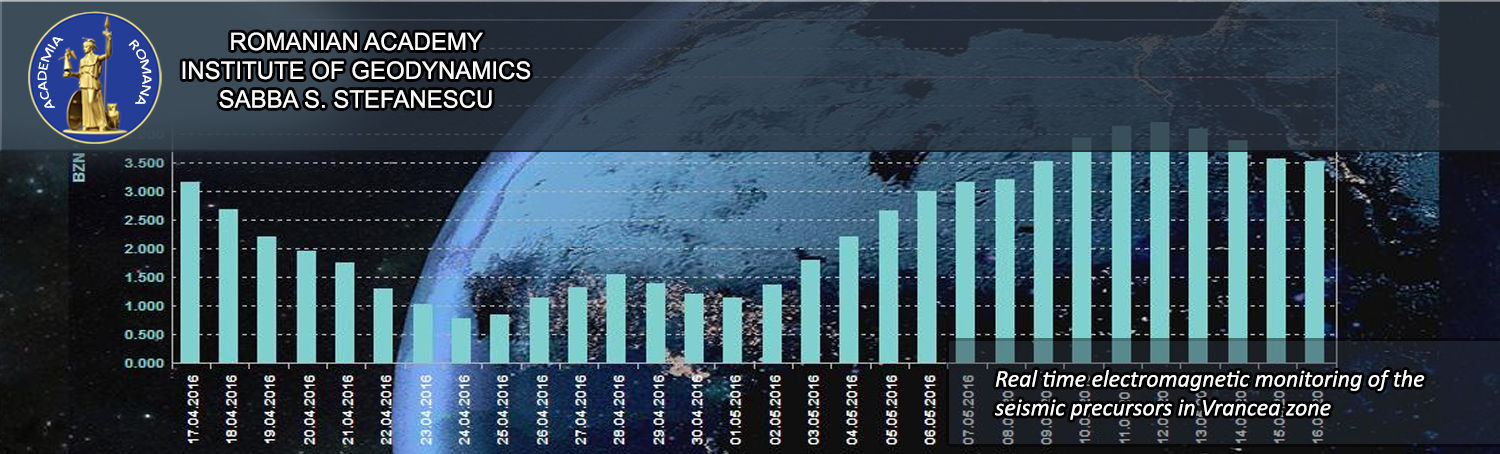
| Cu ocazia Zilei Internaţionale pentru Reducerea Riscului Dezastrelor Naturale (13 octombrie) vă prezentăm realizările departamentului nostru din cadrul Institutului de Geodinamică al Academiei Române |
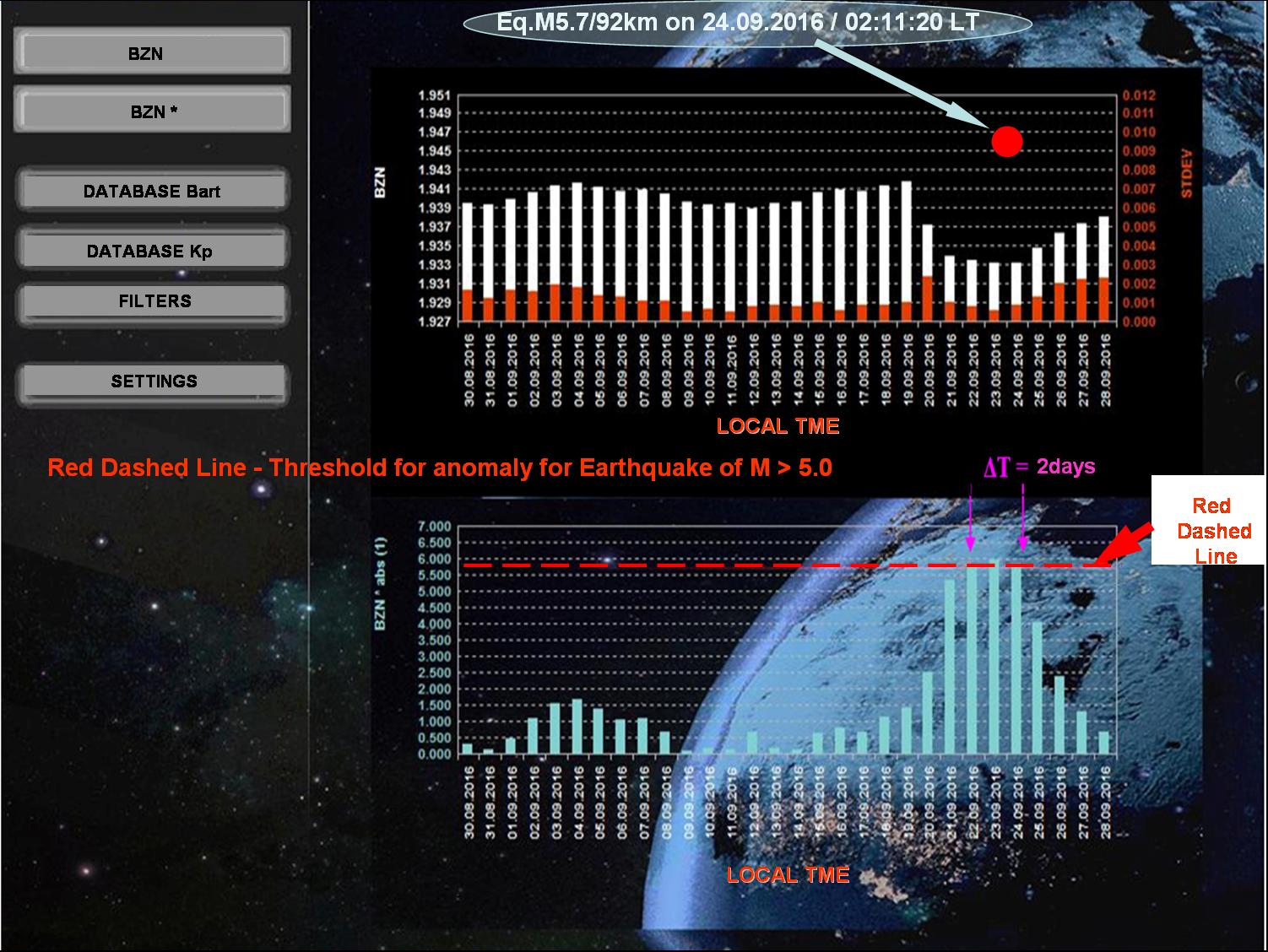 |
| În figura de mai sus se poate observa cum, pentru cutremurul din data de 24 septembrie cu magnitudinea de 5.7, s-a putut emite o alertă încă din data de 22 septembrie, dată la care precursorul seismic geomagnetic a depăşit cu foarte putin limita (linia roşie orizontală din graficul de jos) de la care un cutremur devine important. Pe figură, |